IMAGES TAKEN NEAR TO
Eastgate, LLANELLI, SA15 3YF
Introduction
This page details the photographs taken nearby to Eastgate, SA15 3YF by members of the Geograph project.
The Geograph project started in 2005 with the aim of publishing, organising and preserving representative images for every square kilometre of Great Britain, Ireland and the Isle of Man.

There are currently over 7.5m images from over14,400 individuals and you can help contribute to the project by visiting https://www.geograph.org.uk
Image Map (Loading...)


Getting Data...Please wait
Leaflet Map data © OpenStreetMap
Images are licensed for reuse under creativecommons.org/licenses/by-sa/2.0
Notes
- Clicking on the map will re-center to the selected point.
- The higher the marker number, the further away the image location is from the centre of the postcode.
Image Listing (130 Images Found)
Images are licensed for reuse under creativecommons.org/licenses/by-sa/2.0
Image
Details
Distance
3
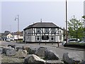
Island House public house
The Island House pub as it was in 2007. At this time it was one of the only buildings left in an area scheduled for development. It has since been demolished to make way for a new cinema and entertainment centre.
Image: © Hywel Williams
Taken: 24 Apr 2007
0.04 miles
4
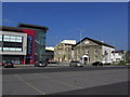
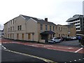
Ffwrnes, Llanelli
The Ffwrnes theatre and Park Street in a burst of sharp evening sunlight after heavy rain.
Image: © Mike Parker
Taken: 21 Sep 2023
0.04 miles
5
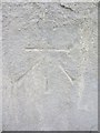
Ordnance Survey Cut Mark
This OS cut mark can be found on the Zion Baptist Chapel. It marks a point 10.552m above mean sea level. http://www.geograph.org.uk/photo/3840640
Image: © Adrian Dust
Taken: 8 Feb 2014
0.04 miles
6
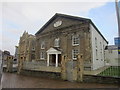
Zion Baptist Chapel
There is an OS cut mark on the east angle of the chapel. http://www.geograph.org.uk/photo/3840638
Image: © Adrian Dust
Taken: 8 Feb 2014
0.05 miles
7
Stepney Hotel, Llanelli
One of Llanelli's more historic buildings, the Stepney Hotel, on the corner of Park Street is scheduled for imminent demolition. Originally built in 1761, the current building’s structure is believed to date from the 1850s or earlier. Unfortunately, it seems the planning department didn’t realise this building’s significance to the town’s history (or chose to ignore it) and along with other more recent nearby buildings is about to be wiped away in the name of progress.
In its last days, the building is no longer a hotel, with many of the upper levels no longer in use. It now houses the Sol Bar (now also closed pending demolition).
Image: © Hywel Williams
Taken: 28 Sep 2006
0.05 miles
8
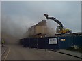
Demolition of upper Park Street
On this day, a row of shops in what's left of Park Street Image that were once a thriving part of Llanelli town centre is finally demolished to make way for modernity's sake. Decay started long ago but was hastened when bypass was built blocking off through access.
Image: © Hywel Williams
Taken: 7 Nov 2006
0.05 miles
9
Stepney Hotel, viewed from the rear
One of Llanelli's more historic buildings, the Stepney Hotel. Originally built in 1761, the current building’s structure is believed to date from the 1850s or earlier. Unfortunately, it seems the planning department didn’t realise this building’s significance to the town’s history (or chose to ignore it) and along with other more recent nearby buildings is about to be demolished. It'll only be missed when it's gone.
Image: © Hywel Williams
Taken: 28 Sep 2006
0.05 miles
10
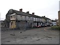
Upper Park Street, Llanelli
Not long ago, the first building on this terraced street, already scheduled for demolition, burned down (suspected arson). Since then, it's been cordoned off. This street is now cordoned off ready for imminent demolition.
Edit: 03/10/06 new thick blue barriers were observed around the entire site - new picture required :)
Image: © Hywel Williams
Taken: 28 Sep 2005
0.05 miles