IMAGES TAKEN NEAR TO
Panteg, LLANELLI, SA15 3TF
Introduction
This page details the photographs taken nearby to Panteg, SA15 3TF by members of the Geograph project.
The Geograph project started in 2005 with the aim of publishing, organising and preserving representative images for every square kilometre of Great Britain, Ireland and the Isle of Man.

There are currently over 7.5m images from over14,400 individuals and you can help contribute to the project by visiting https://www.geograph.org.uk
Image Map (Loading...)


Getting Data...Please wait
Leaflet Map data © OpenStreetMap
Images are licensed for reuse under creativecommons.org/licenses/by-sa/2.0
Notes
- Clicking on the map will re-center to the selected point.
- The higher the marker number, the further away the image location is from the centre of the postcode.
Image Listing (24 Images Found)
Images are licensed for reuse under creativecommons.org/licenses/by-sa/2.0
Image
Details
Distance
1
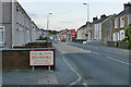
The A476 entering Felinfoel
On the edge of Llanelli
Image: © David Lally
Taken: 9 Jun 2013
0.05 miles
2
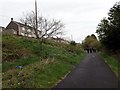
Site of Pleasant View level crossing in Felinfoel
View east along the railway route, note the still-extant crossing indicator for drivers of trains.
Image: © Gareth James
Taken: 18 Mar 2023
0.07 miles
3
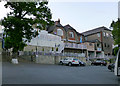
Diplomat Hotel
Hotel in the Best Western chain, right on the edge of Llanelli
Image: © David Lally
Taken: 9 Jun 2013
0.08 miles
4
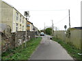
Llwybr Seiclo Felinfoel / Felinfoel Cycle Path
Cerddwyr yn dilyn hen reilfordd ond sy bellach yn llwybr seiclo.
Walkers following an old railway line which is today a cycle path.
Image: © Alan Richards
Taken: 1 May 2016
0.11 miles
5
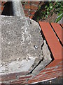
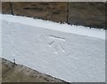
Ordnance Survey Rivet
This OS rivet can be found on the wall between No1 & No3 Maes Golau. It marks a point 33.711m above mean sea level.
Image: © Adrian Dust
Taken: 17 Aug 2014
0.11 miles
6
Rivet Llanelli 3 Maes Golau
Rivet on wall, 3 Maes Golau, Felinfoel
Image: © John Jenkins
Taken: 13 Jan 2023
0.11 miles
7
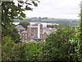
Felinfoel Brewery
from the dismantled railway cycle path
Image: © Ronald John Saunders
Taken: 23 Jul 2003
0.13 miles
8
Maes Golau
1950s council houses in Llanelli.
Image: © Burgess Von Thunen
Taken: 25 Jan 2012
0.13 miles
9
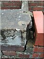
Ordnance Survey Cut Mark
This OS cut mark can be found on No200 Felin-foel Road. It marks a point 37.012m above mean sea level.
Image: © Adrian Dust
Taken: 3 Jun 2020
0.13 miles
10
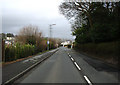
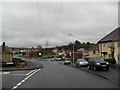
Stretch of road in Llanelli
Stretch of road looking North East.
Image: © Dara Jasumani
Taken: 31 Mar 2006
0.14 miles