IMAGES TAKEN NEAR TO
Llanerch Terrace, LLANELLI, SA15 3RR
Introduction
This page details the photographs taken nearby to Llanerch Terrace, SA15 3RR by members of the Geograph project.
The Geograph project started in 2005 with the aim of publishing, organising and preserving representative images for every square kilometre of Great Britain, Ireland and the Isle of Man.

There are currently over 7.5m images from over14,400 individuals and you can help contribute to the project by visiting https://www.geograph.org.uk
Image Map (Loading...)


Getting Data...Please wait
Leaflet Map data © OpenStreetMap
Images are licensed for reuse under creativecommons.org/licenses/by-sa/2.0
Notes
- Clicking on the map will re-center to the selected point.
- The higher the marker number, the further away the image location is from the centre of the postcode.
Image Listing (16 Images Found)
Images are licensed for reuse under creativecommons.org/licenses/by-sa/2.0
Image
Details
Distance
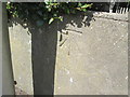
1
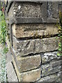
Ordnance Survey Cut Mark
This OS cut mark can be found on the wall of No1 Llannerch Cottages. It marks a point 34.964m above mean sea level.
Image: © Adrian Dust
Taken: 17 Aug 2014
0.03 miles
2
Ordnance Survey Cut Mark
This OS cut mark can be found on No6 Corporation Avenue. It marks a point 20.736m above mean sea level.
Image: © Adrian Dust
Taken: 17 Aug 2014
0.08 miles
3
Ordnance Survey Cut Mark
This OS cut mark can be found on the wall of No40 Corporation Avenue. It marks a point 34.726m above mean sea level.
Image: © Adrian Dust
Taken: 17 Aug 2014
0.11 miles
4
Ordnance Survey Cut Mark
This OS cut mark can be found on the wall of No55 Cilgant Lliedi. It marks a point 16.849m above mean sea level.
Image: © Adrian Dust
Taken: 17 Aug 2014
0.11 miles
5
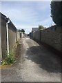
Back lane
Lane behind houses in Felinfoel Road.
Image: © Alan Hughes
Taken: 1 Jun 2019
0.16 miles
6
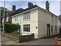
Old tollgate house on Felinfoel Road
Site of the old tollgate attacked in the Rebecca riots of 1843. See also Image
Image: © Alan Hughes
Taken: 1 Jun 2019
0.18 miles
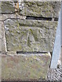
7
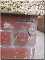
Ordnance Survey Cut Mark
This OS cut mark can be found on No2 Maestir. It marks a point 38.036m above mean sea level.
Image: © Adrian Dust
Taken: 17 Aug 2014
0.18 miles
8
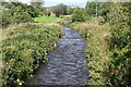
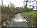
Afon Lliedi above road bridge, Heol Goffa
Urban river between grassland by Rhydyrafon and Llanerch & Penygaer Playing Field, right.
Image: © M J Roscoe
Taken: 1 Oct 2021
0.19 miles
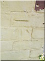
9
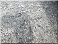
Ordnance Survey Rivet
This OS rivet can be found on the north parapet of the bridge on Heol Goffa. It marks a point 18.468m above mean sea level. http://www.geograph.org.uk/photo/4123489
Image: © Adrian Dust
Taken: 17 Aug 2014
0.19 miles