IMAGES TAKEN NEAR TO
Union Buildings, LLANELLI, SA15 3JP
Introduction
This page details the photographs taken nearby to Union Buildings, SA15 3JP by members of the Geograph project.
The Geograph project started in 2005 with the aim of publishing, organising and preserving representative images for every square kilometre of Great Britain, Ireland and the Isle of Man.

There are currently over 7.5m images from over14,400 individuals and you can help contribute to the project by visiting https://www.geograph.org.uk
Image Map (Loading...)


Getting Data...Please wait
Leaflet Map data © OpenStreetMap
Images are licensed for reuse under creativecommons.org/licenses/by-sa/2.0
Notes
- Clicking on the map will re-center to the selected point.
- The higher the marker number, the further away the image location is from the centre of the postcode.
Image Listing (41 Images Found)
Images are licensed for reuse under creativecommons.org/licenses/by-sa/2.0
Image
Details
Distance
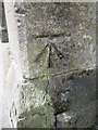
1
Ordnance Survey Cut Mark
This OS cut mark can be found on the wall NE of No41 Union Buildings. It marks a point 39.545m above mean sea level.
Image: © Adrian Dust
Taken: 10 May 2021
0.02 miles
2
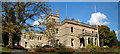
Parc Howard museum
Parc Howard museum from the drive.
Image: © Dara Jasumani
Taken: 26 Apr 2005
0.04 miles
3

Parc Howard Museum
Park Howard Museum, taken from the park's bandstand. This image was taken from exactly the same location as this 1955 picture from the Frith collection: http://www.francisfrith.com/search/wales/dyfed/llanelli/photos/llanelli_L73090.htm
Image: © Hywel Williams
Taken: 9 Jan 2007
0.06 miles
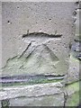
4
Ordnance Survey Cut Mark
This OS cut mark can be found on the gatepost of Parc Howard. It marks a point 42.995m above mean sea level.
Image: © Adrian Dust
Taken: 22 Jun 2014
0.06 miles
5
Ordnance Survey Cut Mark
This OS cut mark can be found on the north angle of Capel Newydd. It marks a point 30.84m above mean sea level. http://www.geograph.org.uk/photo/3840656
Image: © Adrian Dust
Taken: 8 Feb 2014
0.08 miles
6

Ordnance Survey Cut Mark
This OS cut mark can be found on the stone gatepost at the entrance to the cemetery. It marks a point 38.463m above mean sea level. http://www.geograph.org.uk/photo/3840666
Image: © Adrian Dust
Taken: 8 Feb 2014
0.08 miles
7

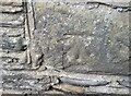
Cemetery Entrance
There is an OS cut mark on the left gatepost. http://www.geograph.org.uk/photo/3840663
Image: © Adrian Dust
Taken: 8 Feb 2014
0.09 miles
8

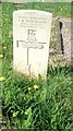
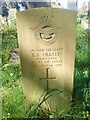
Graveyard at Sunnyhill
The graveyard is connected with St Elli church, about half a mile away.
Image: © Deborah Tilley
Taken: 19 Apr 2009
0.09 miles