IMAGES TAKEN NEAR TO
Thomas Street, LLANELLI, SA15 3JH
Introduction
This page details the photographs taken nearby to Thomas Street, SA15 3JH by members of the Geograph project.
The Geograph project started in 2005 with the aim of publishing, organising and preserving representative images for every square kilometre of Great Britain, Ireland and the Isle of Man.

There are currently over 7.5m images from over14,400 individuals and you can help contribute to the project by visiting https://www.geograph.org.uk
Image Map
Images are licensed for reuse under creativecommons.org/licenses/by-sa/2.0
Notes
- Clicking on the map will re-center to the selected point.
- The higher the marker number, the further away the image location is from the centre of the postcode.
Image Listing (151 Images Found)
Images are licensed for reuse under creativecommons.org/licenses/by-sa/2.0
Image
Details
Distance
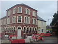
1
Tourist Information Office
This small building which houses the tourist information office was almost certainly once a vestry for the methodist church - the two buildings are actually connected.
Image: © Hywel Williams
Taken: 15 Mar 2007
0.02 miles
2
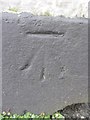
Ordnance Survey Cut Mark
This OS cut mark can be found on No24 Goring Road. It marks a point 18.514m above mean sea level.
Image: © Adrian Dust
Taken: 8 Feb 2014
0.03 miles
3
The Verandah Restaurant
Situated in Bridge Street, a conservation area of Llanelli, the tandoori restaurant recently won an award for the renovation of the historic building (not many left in Llanelli now). It was a popular pub back in the 80's when I lived here.
I can just remember from the 60's when I was a child, the lane of old houses running to the side of the church. It was in a poor state of repair and was probably cobbled. Dad used to drive his car up there for us girls as we enjoyed the bumpy ride. It was known to us as 'Bumpy Lane'!
Image: © Deborah Tilley
Taken: 8 Dec 2008
0.04 miles
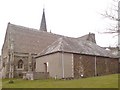
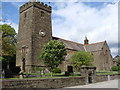
5
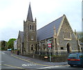
West side of Hall Street Methodist Church, Llanelli
This is the Goring Road side of the church on the corner of Hall Street.
The church was built in several phases during the 19th century. The first phase was completed in 1856 to the design of Bath architect James Wilson. A late 19th century phase was the construction of the tower and spire, completed in 1896.
Image: © Jaggery
Taken: 8 Apr 2012
0.05 miles
6
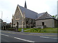
Hall Street side of Hall Street Methodist Church, Llanelli
The church, occupying the corner of Hall Street and Goring Road, was built in several phases during the 19th century. The first phase was completed in 1856 to the design of Bath architect James Wilson.
A late 19th century phase was the construction of the tower and spire on the Goring Road side, http://www.geograph.org.uk/photo/3333941 completed in 1896.
Image: © Jaggery
Taken: 8 Apr 2012
0.05 miles
7
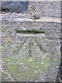
Ordnance Survey Cut Mark
This OS cut mark can be found on the front of the Methodist Chapel on Hall Street. It marks a point 8.8057m above mean sea level.
Image: © Adrian Dust
Taken: 8 Feb 2014
0.05 miles
8
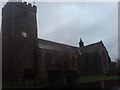
Llanelli Parish Church
Opposite Llanelli House, a grand Georgian building undergoing restoration.
Image: © Deborah Tilley
Taken: 8 Dec 2008
0.06 miles
10
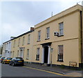
A row of late Georgian houses, Goring Road, viewed from the east, Llanelli
Each of the houses, located at the eastern end of Goring Road, is individually Grade II listed.
http://www.geograph.org.uk/photo/3340609 to a view from the west.
Image: © Jaggery
Taken: 8 Apr 2012
0.06 miles