IMAGES TAKEN NEAR TO
Old Road, LLANELLI, SA15 3HW
Introduction
This page details the photographs taken nearby to Old Road, SA15 3HW by members of the Geograph project.
The Geograph project started in 2005 with the aim of publishing, organising and preserving representative images for every square kilometre of Great Britain, Ireland and the Isle of Man.

There are currently over 7.5m images from over14,400 individuals and you can help contribute to the project by visiting https://www.geograph.org.uk
Image Map (Loading...)


Getting Data...Please wait
Leaflet Map data © OpenStreetMap
Images are licensed for reuse under creativecommons.org/licenses/by-sa/2.0
Notes
- Clicking on the map will re-center to the selected point.
- The higher the marker number, the further away the image location is from the centre of the postcode.
Image Listing (105 Images Found)
Images are licensed for reuse under creativecommons.org/licenses/by-sa/2.0
Image
Details
Distance
1
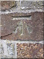
Ordnance Survey Cut Mark
This OS cut mark can be found next to the entrance gate of the school on Old Road. It marks a point 31.050m above mean sea level.
Image: © Adrian Dust
Taken: 1 Jun 2014
0.05 miles
2

The Thomas Arms
The Thomas Arms with the Georgian houses of Goring Street in the distance. Jenkins the Bakers is on the street corner (one of a chain of 5-6 bakers shops in Llanelli) and there's a public phone box just to its right.
Image: © Hywel Williams
Taken: 13 Mar 2007
0.06 miles
3

Cemetery Entrance
There is an OS cut mark on the left gatepost. http://www.geograph.org.uk/photo/3840663
Image: © Adrian Dust
Taken: 8 Feb 2014
0.07 miles
4
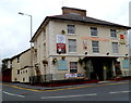
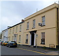
The Thomas Arms hotel, Llanelli
The Thomas Street hotel has 10 guest rooms. There are two lounges for eating, meeting and drinking.
Image: © Jaggery
Taken: 8 Apr 2012
0.08 miles
5
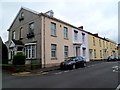
A row of late Georgian houses, Goring Road, viewed from the west, Llanelli
Each of the houses, located at the eastern end of Goring Road, is individually Grade II listed.
http://www.geograph.org.uk/photo/3340610 to a view from the east
Image: © Jaggery
Taken: 8 Apr 2012
0.08 miles
6

Ordnance Survey Cut Mark
This OS cut mark can be found on the stone gatepost at the entrance to the cemetery. It marks a point 38.463m above mean sea level. http://www.geograph.org.uk/photo/3840666
Image: © Adrian Dust
Taken: 8 Feb 2014
0.08 miles
7
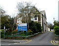
Brynmair Clinic, Llanelli
National Health Service clinic at 11 Goring Road.
Image: © Jaggery
Taken: 8 Apr 2012
0.09 miles
8
A row of late Georgian houses, Goring Road, viewed from the east, Llanelli
Each of the houses, located at the eastern end of Goring Road, is individually Grade II listed.
http://www.geograph.org.uk/photo/3340609 to a view from the west.
Image: © Jaggery
Taken: 8 Apr 2012
0.09 miles
9
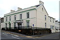
Caeffair Nursing Home, Llanelli
The privately-owned care home is located at 2-4 Felinfoel Road, on the corner of Gilbert Crescent, facing The Thomas Arms. http://www.geograph.org.uk/photo/3340612
Image: © Jaggery
Taken: 8 Apr 2012
0.09 miles
10
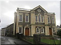
Capel Newydd
There is an OS cut mark on the north angle of the chapel. http://www.geograph.org.uk/photo/3840652
Image: © Adrian Dust
Taken: 8 Feb 2014
0.09 miles