IMAGES TAKEN NEAR TO
Old Road, LLANELLI, SA15 3HS
Introduction
This page details the photographs taken nearby to Old Road, SA15 3HS by members of the Geograph project.
The Geograph project started in 2005 with the aim of publishing, organising and preserving representative images for every square kilometre of Great Britain, Ireland and the Isle of Man.

There are currently over 7.5m images from over14,400 individuals and you can help contribute to the project by visiting https://www.geograph.org.uk
Image Map
Images are licensed for reuse under creativecommons.org/licenses/by-sa/2.0
Notes
- Clicking on the map will re-center to the selected point.
- The higher the marker number, the further away the image location is from the centre of the postcode.
Image Listing (89 Images Found)
Images are licensed for reuse under creativecommons.org/licenses/by-sa/2.0
Image
Details
Distance
1
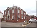
Llanelli Masonic Hall
On the corner of Harries Avenue and Harries Lane, this is Llanelli's Masonic Hall.
Image: © Hywel Williams
Taken: 15 Mar 2007
0.05 miles
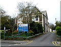
2
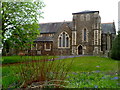
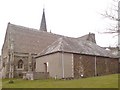
Former All Saints Church, Llanelli
Viewed from Goring Road. The church was consecrated in September 1874, and enlarged in 1887-1888. It was closed down in 2011. Parishioners who formerly worshipped here can attend Church in Wales services at nearby St Elli Parish Church http://www.geograph.org.uk/photo/1077453 in Bridge Street.
Image: © Jaggery
Taken: 8 Apr 2012
0.07 miles
3
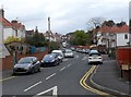
Harries Avenue, Llanelli
A view NE from the New Road end.
Image: © Jaggery
Taken: 8 Apr 2012
0.08 miles
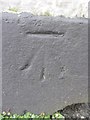
4
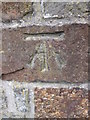
Ordnance Survey Cut Mark
This OS cut mark can be found next to the entrance gate of the school on Old Road. It marks a point 31.050m above mean sea level.
Image: © Adrian Dust
Taken: 1 Jun 2014
0.08 miles
5
Brynmair Clinic, Llanelli
National Health Service clinic at 11 Goring Road.
Image: © Jaggery
Taken: 8 Apr 2012
0.10 miles
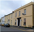
6
WRW Group office, Llanelli
This is the Goring Road office of WRW Group,
a construction and development company operating in mid and south Wales.
Image: © Jaggery
Taken: 8 Apr 2012
0.11 miles
7
Ordnance Survey Cut Mark
This OS cut mark can be found on No24 Goring Road. It marks a point 18.514m above mean sea level.
Image: © Adrian Dust
Taken: 8 Feb 2014
0.11 miles
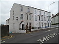
8
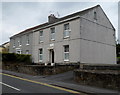
A row of late Georgian houses, Goring Road, viewed from the east, Llanelli
Each of the houses, located at the eastern end of Goring Road, is individually Grade II listed.
http://www.geograph.org.uk/photo/3340609 to a view from the west.
Image: © Jaggery
Taken: 8 Apr 2012
0.11 miles
9
Llanelli Centre For The Deaf
The registered charity's centre is at 54 New Road, Llanelli.
Image: © Jaggery
Taken: 8 Apr 2012
0.12 miles
10
Tourist Information Office
This small building which houses the tourist information office was almost certainly once a vestry for the methodist church - the two buildings are actually connected.
Image: © Hywel Williams
Taken: 15 Mar 2007
0.12 miles