IMAGES TAKEN NEAR TO
Brynamlwg, LLANELLI, SA15 3HQ
Introduction
This page details the photographs taken nearby to Brynamlwg, SA15 3HQ by members of the Geograph project.
The Geograph project started in 2005 with the aim of publishing, organising and preserving representative images for every square kilometre of Great Britain, Ireland and the Isle of Man.

There are currently over 7.5m images from over14,400 individuals and you can help contribute to the project by visiting https://www.geograph.org.uk
Image Map (Loading...)


Getting Data...Please wait
Leaflet Map data © OpenStreetMap
Images are licensed for reuse under creativecommons.org/licenses/by-sa/2.0
Notes
- Clicking on the map will re-center to the selected point.
- The higher the marker number, the further away the image location is from the centre of the postcode.
Image Listing (15 Images Found)
Images are licensed for reuse under creativecommons.org/licenses/by-sa/2.0
Image
Details
Distance
1
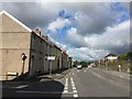
Road junction
Swansea Road at junction with Penallt Road.
Image: © Alan Hughes
Taken: 7 Sep 2018
0.03 miles
2
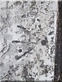
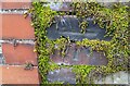
Ordnance Survey Pivot
This OS pivot can be found on the window sill of No11 Box Terrace. It marks a point 29.75m above mean sea level.
Image: © Adrian Dust
Taken: 22 Jun 2014
0.03 miles
3
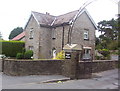
The Lodge at Llanelli District Cemetery
Known to countless generations as Box Cemetery.Not for obvious reasons as there was a Box Colliery there previously
Image: © Ronald John Saunders
Taken: 22 Jan 2002
0.09 miles
4
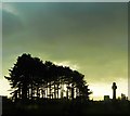
Box Cemetery
A dramatic sky at dusk in winter
Image: © Deborah Tilley
Taken: 8 Dec 2012
0.13 miles
5
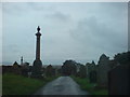
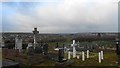
Box Cemetery
On elevated ground with 360 degree views (not much use to the occupants though) this municipal graveyard dates from Victorian times and has some spectacular monuments. It has grown immensely over the years and it cannot be long now before a new final resting place will have to be found for Llanelli's inhabitants.
Image: © Deborah Tilley
Taken: 31 Aug 2008
0.14 miles
7
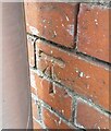
Ordnance Survey Cut Mark
This OS cut mark can be found on the wall at Woodland, Capel Road. It marks a point 24.311m above mean sea level.
Image: © Adrian Dust
Taken: 10 May 2021
0.15 miles
8
Ordnance Survey Cut Mark
This OS cut mark can be found on the wall of Llewen, Capel Road. It marks a point 30.745m above mean sea level.
Image: © Adrian Dust
Taken: 10 May 2021
0.16 miles
9
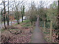
Llwybr Heol Penallt / Penallt Road Path
Llwybr cyhoeddus yn gyfochrog a'r A484 wrth iddo agosau at Heol Penallt.
A public footpath runs parallel with the A484 as it approaches Penallt Road (trans. top of the wooded hill).
Image: © Alan Richards
Taken: 30 Jan 2018
0.19 miles
10
Box Cemetery
Looking towards Swiss Valley on the distant hill
Image: © Deborah Tilley
Taken: 8 Dec 2012
0.21 miles