1
Ordnance Survey Cut Mark
This OS cut mark can be found on No24 Goring Road. It marks a point 18.514m above mean sea level.
Image: © Adrian Dust
Taken: 8 Feb 2014
0.01 miles
2
Tourist Information Office
This small building which houses the tourist information office was almost certainly once a vestry for the methodist church - the two buildings are actually connected.
Image: © Hywel Williams
Taken: 15 Mar 2007
0.03 miles
3
Brynmair Clinic, Llanelli
National Health Service clinic at 11 Goring Road.
Image: © Jaggery
Taken: 8 Apr 2012
0.03 miles
4
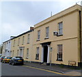
A row of late Georgian houses, Goring Road, viewed from the east, Llanelli
Each of the houses, located at the eastern end of Goring Road, is individually Grade II listed.
http://www.geograph.org.uk/photo/3340609 to a view from the west.
Image: © Jaggery
Taken: 8 Apr 2012
0.03 miles
5
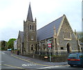
Former All Saints Church, Llanelli
Viewed from Goring Road. The church was consecrated in September 1874, and enlarged in 1887-1888. It was closed down in 2011. Parishioners who formerly worshipped here can attend Church in Wales services at nearby St Elli Parish Church http://www.geograph.org.uk/photo/1077453 in Bridge Street.
Image: © Jaggery
Taken: 8 Apr 2012
0.05 miles
6
West side of Hall Street Methodist Church, Llanelli
This is the Goring Road side of the church on the corner of Hall Street.
The church was built in several phases during the 19th century. The first phase was completed in 1856 to the design of Bath architect James Wilson. A late 19th century phase was the construction of the tower and spire, completed in 1896.
Image: © Jaggery
Taken: 8 Apr 2012
0.05 miles
7
WRW Group office, Llanelli
This is the Goring Road office of WRW Group,
a construction and development company operating in mid and south Wales.
Image: © Jaggery
Taken: 8 Apr 2012
0.06 miles
8
Hall Street side of Hall Street Methodist Church, Llanelli
The church, occupying the corner of Hall Street and Goring Road, was built in several phases during the 19th century. The first phase was completed in 1856 to the design of Bath architect James Wilson.
A late 19th century phase was the construction of the tower and spire on the Goring Road side, http://www.geograph.org.uk/photo/3333941 completed in 1896.
Image: © Jaggery
Taken: 8 Apr 2012
0.06 miles
9
A row of late Georgian houses, Goring Road, viewed from the west, Llanelli
Each of the houses, located at the eastern end of Goring Road, is individually Grade II listed.
http://www.geograph.org.uk/photo/3340610 to a view from the east
Image: © Jaggery
Taken: 8 Apr 2012
0.06 miles
10
The Verandah Restaurant
Situated in Bridge Street, a conservation area of Llanelli, the tandoori restaurant recently won an award for the renovation of the historic building (not many left in Llanelli now). It was a popular pub back in the 80's when I lived here.
I can just remember from the 60's when I was a child, the lane of old houses running to the side of the church. It was in a poor state of repair and was probably cobbled. Dad used to drive his car up there for us girls as we enjoyed the bumpy ride. It was known to us as 'Bumpy Lane'!
Image: © Deborah Tilley
Taken: 8 Dec 2008
0.06 miles


