IMAGES TAKEN NEAR TO
Woodend Road, LLANELLI, SA15 3BQ
Introduction
This page details the photographs taken nearby to Woodend Road, SA15 3BQ by members of the Geograph project.
The Geograph project started in 2005 with the aim of publishing, organising and preserving representative images for every square kilometre of Great Britain, Ireland and the Isle of Man.

There are currently over 7.5m images from over14,400 individuals and you can help contribute to the project by visiting https://www.geograph.org.uk
Image Map (Loading...)


Getting Data...Please wait
Leaflet Map data © OpenStreetMap
Images are licensed for reuse under creativecommons.org/licenses/by-sa/2.0
Notes
- Clicking on the map will re-center to the selected point.
- The higher the marker number, the further away the image location is from the centre of the postcode.
Image Listing (21 Images Found)
Images are licensed for reuse under creativecommons.org/licenses/by-sa/2.0
Image
Details
Distance
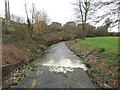
1
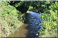
Afon Lleidi near Andrew Street
Looking upstream from footpath at the northern end of Andrew Street.
Image: © M J Roscoe
Taken: 1 Oct 2021
0.07 miles
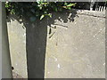
2
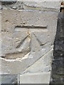
Ordnance Survey Cut Mark
This OS cut mark can be found on a post in the wall of the Glenalla Methodist Chapel. It marks a point 18.980m above mean sea level. http://www.geograph.org.uk/photo/4080091
Image: © Adrian Dust
Taken: 20 Jul 2014
0.14 miles
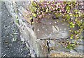
3
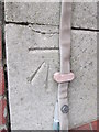
Ordnance Survey Cut Mark
This OS cut mark can be found on the Old Nurses Home on Palace Avenue. It marks a point 33.674m above mean sea level. http://www.geograph.org.uk/photo/4080076
Image: © Adrian Dust
Taken: 20 Jul 2014
0.14 miles
4
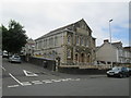
Glenalla Methodist Chapel
There is an Ordnance Survey cut mark on a wall post of the chapel. http://www.geograph.org.uk/photo/4080086
Image: © Adrian Dust
Taken: 20 Jul 2014
0.14 miles
5
Ordnance Survey Cut Mark
This OS cut mark can be found on the wall of No55 Cilgant Lliedi. It marks a point 16.849m above mean sea level.
Image: © Adrian Dust
Taken: 17 Aug 2014
0.16 miles
6
Ordnance Survey Cut Mark
This OS cut mark can be found on the wall NE side of the lane. It marks a point 18.934m above mean sea level.
Image: © Adrian Dust
Taken: 10 May 2021
0.18 miles
7
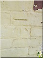
Ordnance Survey Cut Mark
This OS cut mark can be found on No6 Corporation Avenue. It marks a point 20.736m above mean sea level.
Image: © Adrian Dust
Taken: 17 Aug 2014
0.20 miles
9
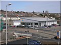
Aldi Supermarket
Adjacent to the last remnants of the old Buckley's Brewery (now a listed building), this new Aldi store was built in 2006 on land that was previously occupied by the brewery.
Image: © Hywel Williams
Taken: 21 Mar 2007
0.22 miles
10
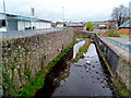
Afon Lliedi alongside Aldi, Llanelli
The Aldi supermarket http://www.geograph.org.uk/photo/3397875 is on the left.
The river looks like a stagnant drainage channel. This view was taken in April 2012 during a prolonged period of below-average rainfall and shortly after a warm March 2012, so perhaps this state of the river is not typical. http://www.geograph.org.uk/photo/3397944 to a view of the same stretch of river in the opposite direction.
Image: © Jaggery
Taken: 8 Apr 2012
0.22 miles