IMAGES TAKEN NEAR TO
Town Hall Square, LLANELLI, SA15 3AP
Introduction
This page details the photographs taken nearby to Town Hall Square, SA15 3AP by members of the Geograph project.
The Geograph project started in 2005 with the aim of publishing, organising and preserving representative images for every square kilometre of Great Britain, Ireland and the Isle of Man.

There are currently over 7.5m images from over14,400 individuals and you can help contribute to the project by visiting https://www.geograph.org.uk
Image Map (Loading...)


Getting Data...Please wait
Leaflet Map data © OpenStreetMap
Images are licensed for reuse under creativecommons.org/licenses/by-sa/2.0
Notes
- Clicking on the map will re-center to the selected point.
- The higher the marker number, the further away the image location is from the centre of the postcode.
Image Listing (147 Images Found)
Images are licensed for reuse under creativecommons.org/licenses/by-sa/2.0
Image
Details
Distance
1
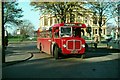
One of eight ? Llanelly 1969
South Wales Transport No.40 passes in front of Llanelly Town Hall. The section of roadway it is using is now part of the public gardens (Spring Gardens) facing the town hall.
It was one of a batch of 8 buses of special design for use on the route to the New Dock area which had a railway bridge with just 9 ft clearance. It has an AEC Regent V chassis (built 1963) which was a double-deck type, these being the only single deck version of the type built. The by-then standard underfloor-engined single-deck bus could not accommodate a low profile body.
This is one of a series of views featuring buses in the 60s, 70s, and 80s. http://www.geograph.org.uk/search.php?i=2114547&displayclass=slide
Image: © Alan Murray-Rust
Taken: 24 Nov 1969
0.04 miles
2
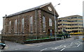
Grade II* listed Tabernacle Chapel, Llanelli
The chapel occupies a site bordered by Coleshill Terrace, Church Street and Coldstream Street.
It was built in 1872-1873. A prominent feature is the four-pillared Corinthian arcade at the entrance. Grade II* listed in December 1992.
Image: © Jaggery
Taken: 8 Apr 2012
0.04 miles
3
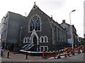
Llanelli Presbyterian Church
The original building was built on 1872.
Image: © Hywel Williams
Taken: 26 Oct 2006
0.04 miles
4
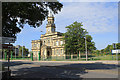
Llanelli Town Hall
View from the road of Llanelli town hall.
Image: © Roger Pagram
Taken: 2 Jul 2011
0.04 miles
5
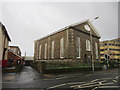
Moriah Baptist Chapel, Llanelli
Located on the corner of Station Road and Old Castle Road. The inscription on the tablet in the pediment shows the year 1870. The church opened for worship on Easter Sunday 1872.
Image: © Jaggery
Taken: 8 Apr 2012
0.05 miles
6
Morian Baptist Chapel
There is an OS cut mark on the Chapel wall. http://www.geograph.org.uk/photo/3840604
Image: © Adrian Dust
Taken: 8 Feb 2014
0.05 miles
7
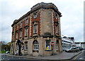
Stamps, Llanelli
Pub on the corner of Station Road and John Street.
Image: © Jaggery
Taken: 8 Apr 2012
0.05 miles
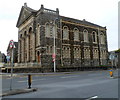
8
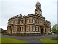
Grade II listed Llanelli Town Hall
The town hall was built in 1894-1896 in the Italianate style.
Grade II listed in May 1987.
Image: © Jaggery
Taken: 8 Apr 2012
0.05 miles
9
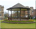
People's Park Bandstand, Llanelli
The bandstand was opened on June 1st 1889. It is located near the town hall http://www.geograph.org.uk/photo/3054862
Image: © Jaggery
Taken: 8 Apr 2012
0.05 miles
10
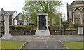
War Memorials, People's Park, Llanelli
There are several memorials here in the NE corner of the park, adjacent to Coleshill Terrace.
In the centre is a statue of a coal miner and a soldier, a reminder of the vital but largely unrecognised contribution made by miners to the war effort in the Second World War. Four memorials on the wall are dedicated to those who were killed in Burma, while serving in the Royal Navy, the Welsh Guards or the Royal Air Force. The plaque on the right is dedicated to those killed in conflicts after the Second World War.
Image: © Jaggery
Taken: 8 Apr 2012
0.05 miles