IMAGES TAKEN NEAR TO
Charles Terrace, LLANELLI, SA15 2UD
Introduction
This page details the photographs taken nearby to Charles Terrace, SA15 2UD by members of the Geograph project.
The Geograph project started in 2005 with the aim of publishing, organising and preserving representative images for every square kilometre of Great Britain, Ireland and the Isle of Man.

There are currently over 7.5m images from over14,400 individuals and you can help contribute to the project by visiting https://www.geograph.org.uk
Image Map (Loading...)


Getting Data...Please wait
Leaflet Map data © OpenStreetMap
Images are licensed for reuse under creativecommons.org/licenses/by-sa/2.0
Notes
- Clicking on the map will re-center to the selected point.
- The higher the marker number, the further away the image location is from the centre of the postcode.
Image Listing (83 Images Found)
Images are licensed for reuse under creativecommons.org/licenses/by-sa/2.0
Image
Details
Distance
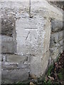
1
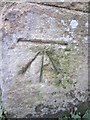
Ordnance Survey Cut Mark
This OS cut mark can be found on the gatepost of Lakefield Road School. It marks a point 8.5253m above mean sea level.
Image: © Adrian Dust
Taken: 27 Feb 2014
0.02 miles
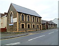
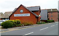
2
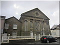
Calvanistic Methodist Siloh Chapel
Lakefield Road.
Image: © Adrian Dust
Taken: 27 Feb 2014
0.06 miles
4
Llanelli Free Evangelical Church
Llanelli Free Evangelical Church, as a congregation, was founded in 1982.
The church building is a converted former synagogue dating from 1908, located on the corner of Queen Victoria Road and Erw Road, Llanelli. The first Evangelical service took place here in November 1988.
Image: © Jaggery
Taken: 8 Apr 2012
0.08 miles
5
Ordnance Survey Cut Mark
This OS cut mark can be found on the East angle of St Peter's Church. It marks a point 9.2141m above mean sea level.
Image: © Adrian Dust
Taken: 27 Feb 2014
0.09 miles
6
Pedestrian crossing
A pedestrian crossing Station Road, Llanelli.
Image: © Alan Hughes
Taken: 26 Jun 2019
0.11 miles
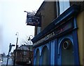
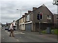
7
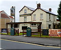
The Vine Inn, Llanelli
Located on the corner of Station Road and Pemberton Street, the Vine Inn looks disused in this view taken in April 2012. Signs on the wall have faded. The empty wall brackets formerly held flower baskets.
Image: © Jaggery
Taken: 8 Apr 2012
0.11 miles
8
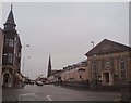
"Greenfield Road" (Recreated)
This is a recreation of the following 1896 picture from the Frith collection: http://www.francisfrith.com/search/wales/dyfed/llanelli/photos/llanelli_38744.htm
The Frith collection describe this as Greenfield Road and indeed the chapel has Greenfield in its name stone, however there is no Greenfield Road here today. The church is on the corner of Murray Street and Station Road, with the photograph being taken in the middle of Queen Victoria Road.
The smaller chapel has been replaced by housing but the other buildings remain largely the same from 1896 to 2007.
Image: © Hywel Williams
Taken: 8 Jan 2007
0.12 miles
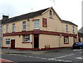
9
The Greenfield Inn, Llanelli
Pub and grill in Erw Road, near the Princess Street/Lloyd Street junction.
Image: © Jaggery
Taken: 8 Apr 2012
0.13 miles
10
Avenue Villa Surgery and Pharmacy, Llanelli
Located on the corner of Brynmor Road and Erw Road.
Image: © Jaggery
Taken: 8 Apr 2012
0.13 miles