1
Houses near the southern end of Queen Victoria Road, Llanelli
Viewed from the corner of Albert Street. The bilingual street name sign on the right shows Victoria in the Welsh part of the name, which is surprising as V is not in the Welsh alphabet. I expected to see Fictoria, or Buddug, which is used as the Welsh form of Victoria on street signs in some parts of Wales, as here. http://www.geograph.org.uk/photo/2137697
Image: © Jaggery
Taken: 8 Apr 2012
0.03 miles
2
Llanelli Free Evangelical Church
Llanelli Free Evangelical Church, as a congregation, was founded in 1982.
The church building is a converted former synagogue dating from 1908, located on the corner of Queen Victoria Road and Erw Road, Llanelli. The first Evangelical service took place here in November 1988.
Image: © Jaggery
Taken: 8 Apr 2012
0.06 miles
3
The Coastal Park Guest Accommodation and Grill, Llanelli
Located at the southern end of Queen Victoria Road, near the Millennium Coastal Park. Formerly two guesthouses, The Victoria on the left, now the Coastal Park's Grill, and Awel Y Mor on the right, now the main accommodation section of The Coastal Park hotel.
Image: © Jaggery
Taken: 8 Apr 2012
0.09 miles
4
The Palms Centre, Llanelli
Two of the occupiers of The Palms Centre, 96 Queen Victoria Road, are R.T.Electrics on the right and the CYCA Wales Training Centre on the left. CYCA (Carmarthenshire Youth and Children's Association) is a registered children's charity operating throughout the county of Carmarthenshire. CYCA provides informal educational and recreational activities for children and young people, and support for families.
Image: © Jaggery
Taken: 8 Apr 2012
0.09 miles
5
Ordnance Survey Cut Mark
This OS cut mark can be found on the gatepost of Lakefield Road School. It marks a point 8.5253m above mean sea level.
Image: © Adrian Dust
Taken: 27 Feb 2014
0.09 miles
6
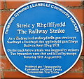
1911 Railway Strike fatalities plaque, Llanelli
The Llanelli Community Heritage blue plaque is on the side of the Queen Victoria Road bridge across railway lines. It records that on Saturday August 19th, 1911 during a railway strike, a train was stopped by strikers on the track below. http://www.geograph.org.uk/photo/2945466 Two bystanders were shot and killed by troops.
It was the last time troops on the British mainland fired on workers during an industrial dispute.
The strike, the first national railway strike in the UK, occurred during a long period of industrial unrest known as the Great Unrest of 1910 to 1914.
Image: © Jaggery
Taken: 8 Apr 2012
0.11 miles
7
The Bay bar & bistro, Llanelli
On the corner of Victoria Square and Bryn Road. The building was formerly the Union Inn.
Image: © Jaggery
Taken: 8 Apr 2012
0.11 miles
8
Avenue Villa Surgery and Pharmacy, Llanelli
Located on the corner of Brynmor Road and Erw Road.
Image: © Jaggery
Taken: 8 Apr 2012
0.12 miles
9
The Greenfield Inn, Llanelli
Pub and grill in Erw Road, near the Princess Street/Lloyd Street junction.
Image: © Jaggery
Taken: 8 Apr 2012
0.12 miles
10
Victoria Road Methodist Church, Llanelli
Image: © Eirian Evans
Taken: 22 May 2022
0.12 miles


