IMAGES TAKEN NEAR TO
Queen Victoria Road, LLANELLI, SA15 2TR
Introduction
This page details the photographs taken nearby to Queen Victoria Road, SA15 2TR by members of the Geograph project.
The Geograph project started in 2005 with the aim of publishing, organising and preserving representative images for every square kilometre of Great Britain, Ireland and the Isle of Man.

There are currently over 7.5m images from over14,400 individuals and you can help contribute to the project by visiting https://www.geograph.org.uk
Image Map (Loading...)


Getting Data...Please wait
Leaflet Map data © OpenStreetMap
Images are licensed for reuse under creativecommons.org/licenses/by-sa/2.0
Notes
- Clicking on the map will re-center to the selected point.
- The higher the marker number, the further away the image location is from the centre of the postcode.
Image Listing (77 Images Found)
Images are licensed for reuse under creativecommons.org/licenses/by-sa/2.0
Image
Details
Distance
1
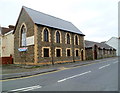
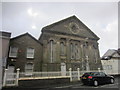
Llanelli Free Evangelical Church
Llanelli Free Evangelical Church, as a congregation, was founded in 1982.
The church building is a converted former synagogue dating from 1908, located on the corner of Queen Victoria Road and Erw Road, Llanelli. The first Evangelical service took place here in November 1988.
Image: © Jaggery
Taken: 8 Apr 2012
0.01 miles
2
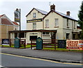
The Greenfield Inn, Llanelli
Pub and grill in Erw Road, near the Princess Street/Lloyd Street junction.
Image: © Jaggery
Taken: 8 Apr 2012
0.05 miles
3
Avenue Villa Surgery and Pharmacy, Llanelli
Located on the corner of Brynmor Road and Erw Road.
Image: © Jaggery
Taken: 8 Apr 2012
0.05 miles
4
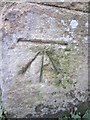
Ordnance Survey Cut Mark
This OS cut mark can be found on the gatepost of Lakefield Road School. It marks a point 8.5253m above mean sea level.
Image: © Adrian Dust
Taken: 27 Feb 2014
0.07 miles
5
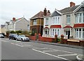
Houses near the southern end of Queen Victoria Road, Llanelli
Viewed from the corner of Albert Street. The bilingual street name sign on the right shows Victoria in the Welsh part of the name, which is surprising as V is not in the Welsh alphabet. I expected to see Fictoria, or Buddug, which is used as the Welsh form of Victoria on street signs in some parts of Wales, as here. http://www.geograph.org.uk/photo/2137697
Image: © Jaggery
Taken: 8 Apr 2012
0.09 miles
6
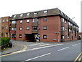
Princess Court, Llanelli
A block of 20 flats on the corner of Princess Street and Erw Road.
Image: © Jaggery
Taken: 8 Apr 2012
0.11 miles
7
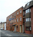
Queens Lofts, Llanelli
Queens Lofts are flats in Princess Street, occupying the converted former Pugh Brothers warehouse and factory. The PUGH BROTHERS name remains on the building. In the 1950s, after a fire here which destroyed all their machinery, Pugh Brothers discontinued making furniture, and instead bought in ready-made furniture from outside manufacturers. Pugh Brothers continued in their Cowell Street premises until closure in the early 21st century.
Image: © Jaggery
Taken: 8 Apr 2012
0.13 miles
8
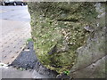
Ordnance Survey Cut Mark (Remains)
This badly damaged OS cut mark can be found on the wall to the NW of Lloyd Street. It marked a point 8.5374m above mean sea level.
Image: © Adrian Dust
Taken: 8 Feb 2014
0.13 miles
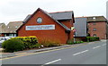
9
Calvanistic Methodist Siloh Chapel
Lakefield Road.
Image: © Adrian Dust
Taken: 27 Feb 2014
0.13 miles
10
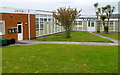
The Palms Centre, Llanelli
Two of the occupiers of The Palms Centre, 96 Queen Victoria Road, are R.T.Electrics on the right and the CYCA Wales Training Centre on the left. CYCA (Carmarthenshire Youth and Children's Association) is a registered children's charity operating throughout the county of Carmarthenshire. CYCA provides informal educational and recreational activities for children and young people, and support for families.
Image: © Jaggery
Taken: 8 Apr 2012
0.14 miles