IMAGES TAKEN NEAR TO
Erw Road, LLANELLI, SA15 2TE
Introduction
This page details the photographs taken nearby to Erw Road, SA15 2TE by members of the Geograph project.
The Geograph project started in 2005 with the aim of publishing, organising and preserving representative images for every square kilometre of Great Britain, Ireland and the Isle of Man.

There are currently over 7.5m images from over14,400 individuals and you can help contribute to the project by visiting https://www.geograph.org.uk
Image Map (Loading...)


Getting Data...Please wait
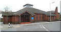
Leaflet Map data © OpenStreetMap
Images are licensed for reuse under creativecommons.org/licenses/by-sa/2.0
Notes
- Clicking on the map will re-center to the selected point.
- The higher the marker number, the further away the image location is from the centre of the postcode.
Image Listing (92 Images Found)
Images are licensed for reuse under creativecommons.org/licenses/by-sa/2.0
Image
Details
Distance
1
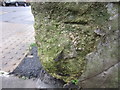
Ordnance Survey Cut Mark (Remains)
This badly damaged OS cut mark can be found on the wall to the NW of Lloyd Street. It marked a point 8.5374m above mean sea level.
Image: © Adrian Dust
Taken: 8 Feb 2014
0.02 miles
2
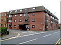
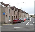
Princess Court, Llanelli
A block of 20 flats on the corner of Princess Street and Erw Road.
Image: © Jaggery
Taken: 8 Apr 2012
0.03 miles
3
Avenue Villa Surgery and Pharmacy, Llanelli
Located on the corner of Brynmor Road and Erw Road.
Image: © Jaggery
Taken: 8 Apr 2012
0.06 miles
4
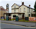
The Greenfield Inn, Llanelli
Pub and grill in Erw Road, near the Princess Street/Lloyd Street junction.
Image: © Jaggery
Taken: 8 Apr 2012
0.06 miles
5
Old Castle Road houses, Llanelli
The houses face Llanelli Delivery Office. http://www.geograph.org.uk/photo/3054783
Image: © Jaggery
Taken: 8 Apr 2012
0.07 miles
6
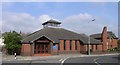
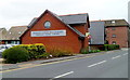
Llanelli Roman Catholic Church
This is the new Roman Catholic Church. The previous building had to be demolished as it was built directly over the course of the submerged river Lliedi and this had caused structural damage to its foundations.
Image: © Hywel Williams
Taken: 18 Oct 2006
0.08 miles
7
Canon Schwarz Hall, Llanelli
Located in Waunlanyrafon alongside Our Lady Queen of Peace RC church. http://www.geograph.org.uk/photo/3054792
The Welsh Y Neuadd Gatholig on the wall means The Catholic Hall.
Image: © Jaggery
Taken: 8 Apr 2012
0.08 miles
8
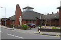
Eastern side of Our Lady Queen of Peace, Llanelli
Roman Catholic parish church located in Waunlanyrafon. The church is part of the diocese of Menevia.
Image: © Jaggery
Taken: 8 Apr 2012
0.08 miles
9
Southern side of Our Lady Queen of Peace, Llanelli
Roman Catholic parish church located in Waunlanyrafon. The church is part of the diocese of Menevia.
Image: © Jaggery
Taken: 8 Apr 2012
0.08 miles
10
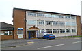
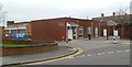
Llanelli Police Station
Part of Dyfed-Powys Police, the station is located in a street named Waunlanyrafon.
Image: © Jaggery
Taken: 8 Apr 2012
0.08 miles