IMAGES TAKEN NEAR TO
Old Castle Road, LLANELLI, SA15 2SL
Introduction
This page details the photographs taken nearby to Old Castle Road, SA15 2SL by members of the Geograph project.
The Geograph project started in 2005 with the aim of publishing, organising and preserving representative images for every square kilometre of Great Britain, Ireland and the Isle of Man.

There are currently over 7.5m images from over14,400 individuals and you can help contribute to the project by visiting https://www.geograph.org.uk
Image Map (Loading...)


Getting Data...Please wait
Leaflet Map data © OpenStreetMap
Images are licensed for reuse under creativecommons.org/licenses/by-sa/2.0
Notes
- Clicking on the map will re-center to the selected point.
- The higher the marker number, the further away the image location is from the centre of the postcode.
Image Listing (117 Images Found)
Images are licensed for reuse under creativecommons.org/licenses/by-sa/2.0
Image
Details
Distance
1
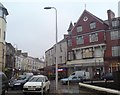
Stepney Street (Recreated)
This is a recreation of the following 1896 picture from the Frith collection: http://www.francisfrith.com/search/wales/dyfed/llanelli/photos/llanelli_38736.htm
Although taken over 110 years after the first picture, many of the buildings are immediately recognisable, with only one modern addition immediately to the picture's left.
The heavy traffic is however new - though on this day, this was compounded by road works.
Image: © Hywel Williams
Taken: 8 Jan 2007
0.01 miles
2
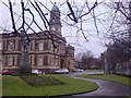
Llanelli Town Hall (Recreated)
This is a recreation of the following 1955 picture from the Frith collection: http://www.francisfrith.com/search/wales/dyfed/llanelli/photos/llanelli_L73057.htm
There's remarkably little difference between the two photographs. The trees behind the spot the picture was taken have obviously grown, the cars are more modern and the little chair on which the lady is sitting in 1955 is no longer there.
Image: © Hywel Williams
Taken: 8 Jan 2007
0.01 miles
3
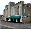
Llanelli : Terry Griffiths Matchroom viewed from the west
Located in the former Ritz dance hall building in Waunlanyrafon, a street in the town centre.
The Matchroom opened here in 1987, set up by former World Professional Snooker champion Terry Griffiths OBE (born in Llanelli in 1947). The Matchroom has 14 championship snooker tables, and is home to the Terry Griffiths Snooker Academy (Wales).
Image: © Jaggery
Taken: 8 Apr 2012
0.01 miles
4
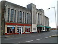
Llanelli : Terry Griffiths Matchroom viewed from the east
Located in the former Ritz dance hall building in Waunlanyrafon, a street in the town centre. The Matchroom opened here in 1987, set up by former World Professional Snooker champion Terry Griffiths OBE (born in Llanelli in 1947). The Matchroom has 14 championship snooker tables, and is home to the Terry Griffiths Snooker Academy (Wales).
Image: © Jaggery
Taken: 8 Apr 2012
0.01 miles
5
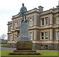
Boer War Memorial, Llanelli
Located near the town hall. http://www.geograph.org.uk/photo/3054862
The memorial commemorates the men of Llanelly (as it was then spelt) and district who died in the war in South Africa (1899-1902), known as the Second Boer War. It was unveiled on August 26th, 1905 by Field Marshal The Right Hon. Earl Roberts, V.C. who was Commander-in-Chief of the forces in South Africa from 1899-1900.
Image: © Jaggery
Taken: 8 Apr 2012
0.01 miles
6
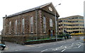
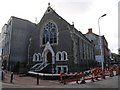
Moriah Baptist Chapel, Llanelli
Located on the corner of Station Road and Old Castle Road. The inscription on the tablet in the pediment shows the year 1870. The church opened for worship on Easter Sunday 1872.
Image: © Jaggery
Taken: 8 Apr 2012
0.04 miles
7
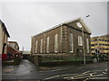
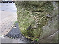
Morian Baptist Chapel
There is an OS cut mark on the Chapel wall. http://www.geograph.org.uk/photo/3840604
Image: © Adrian Dust
Taken: 8 Feb 2014
0.04 miles
8
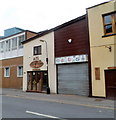
ATC, Lloyd Street, Llanelli
The initials ATC usually indicate the Air Training Corps,
but here it's a carpentry (Acorn Timber Craft) in Lloyd Street.
Image: © Jaggery
Taken: 8 Apr 2012
0.05 miles
9
Llanelli Presbyterian Church
The original building was built on 1872.
Image: © Hywel Williams
Taken: 26 Oct 2006
0.05 miles
10
Ordnance Survey Cut Mark (Remains)
This badly damaged OS cut mark can be found on the wall to the NW of Lloyd Street. It marked a point 8.5374m above mean sea level.
Image: © Adrian Dust
Taken: 8 Feb 2014
0.06 miles