IMAGES TAKEN NEAR TO
Burry Street, LLANELLI, SA15 2NT
Introduction
This page details the photographs taken nearby to Burry Street, SA15 2NT by members of the Geograph project.
The Geograph project started in 2005 with the aim of publishing, organising and preserving representative images for every square kilometre of Great Britain, Ireland and the Isle of Man.

There are currently over 7.5m images from over14,400 individuals and you can help contribute to the project by visiting https://www.geograph.org.uk
Image Map (Loading...)


Getting Data...Please wait
Leaflet Map data © OpenStreetMap
Images are licensed for reuse under creativecommons.org/licenses/by-sa/2.0
Notes
- Clicking on the map will re-center to the selected point.
- The higher the marker number, the further away the image location is from the centre of the postcode.
Image Listing (91 Images Found)
Images are licensed for reuse under creativecommons.org/licenses/by-sa/2.0
Image
Details
Distance
1
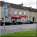
Marine Street Spar, Llanelli
Spar convenience store at 39 Marine Street.
Image: © Jaggery
Taken: 15 Aug 2015
0.02 miles
2

The Cambrian, Marine Street, Llanelli
In August 2015, this is the sole survivor of the dozen licensed premises recorded in Marine Street in the 1870s.
Image: © Jaggery
Taken: 15 Aug 2015
0.03 miles
3
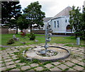
Saucepan sculpture in Llanelli
The focal point of the Seaside Community Gardens in Llanelli, the sculpture is a reminder of Llanelli's major role in the tinplate industry in the 19th and 20th centuries. Steel saucepans and other kitchen utensils were tinplated to provide a cheap supply to the British public. The song known in Welsh as Sosban Fach (Little Saucepan) is sung by supporters of the regional rugby union team The Scarlets and local team Llanelli Rugby Football Club.
Image: © Jaggery
Taken: 15 Aug 2015
0.04 miles
4
St John's Church
There is an OS cut mark on the wall at the junction of Druce Street. http://www.geograph.org.uk/photo/3865877
Image: © Adrian Dust
Taken: 27 Feb 2014
0.04 miles
5
Marine Street, Llanelli
The SE end of Marine Street viewed from the western end of Copperworks Road.
Image: © Jaggery
Taken: 15 Aug 2015
0.04 miles
6
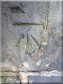
Ordnance Survey Cut Mark
This OS cut mark can be found on the wall of St John's Church, Druce Street. It marks a point 6.7757m above mean sea level. http://www.geograph.org.uk/photo/3865882
Image: © Adrian Dust
Taken: 27 Feb 2014
0.04 miles
7

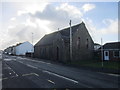
Former St John's Church, Llanelli
The building on the corner of Marine Street and Druce Street was consecrated as St John's Mission Church in March 1887. It was a religious centre of the community of Seaside, Llanelli for more than 120 years.
Image: © Jaggery
Taken: 15 Aug 2015
0.04 miles
8
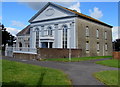
Bethel Baptist Chapel, Llanelli
Located between Glanmor Road and Marine Street, at the edge of St David's Close.
The oval tablet records that this is the 1850 enlargement of the 1840 original.
Image: © Jaggery
Taken: 15 Aug 2015
0.05 miles
9
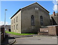
North side of Bethel Baptist Chapel, Llanelli
Viewed from St David's Close. The chapel's best side is its south. http://www.geograph.org.uk/photo/4615816
Image: © Jaggery
Taken: 15 Aug 2015
0.06 miles
10
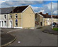
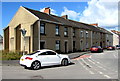
Junction of Bryn Road and Bryn Terrace, Llanelli
Viewed from St David's Close. Bryn Terrace is on the left.
Image: © Jaggery
Taken: 15 Aug 2015
0.07 miles