IMAGES TAKEN NEAR TO
Glanmor Road, LLANELLI, SA15 2LT
Introduction
This page details the photographs taken nearby to Glanmor Road, SA15 2LT by members of the Geograph project.
The Geograph project started in 2005 with the aim of publishing, organising and preserving representative images for every square kilometre of Great Britain, Ireland and the Isle of Man.

There are currently over 7.5m images from over14,400 individuals and you can help contribute to the project by visiting https://www.geograph.org.uk
Image Map (Loading...)


Getting Data...Please wait
Leaflet Map data © OpenStreetMap
Images are licensed for reuse under creativecommons.org/licenses/by-sa/2.0
Notes
- Clicking on the map will re-center to the selected point.
- The higher the marker number, the further away the image location is from the centre of the postcode.
Image Listing (152 Images Found)
Images are licensed for reuse under creativecommons.org/licenses/by-sa/2.0
Image
Details
Distance
1
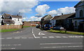
Junction of Copperworks Road and Glanmor Road, Llanelli
Glanmor Road heads north away from Copperworks Road near the Marine Street junction.
The boarded-up window on the right is part of the former Siloah chapel. http://www.geograph.org.uk/photo/4615676
Image: © Jaggery
Taken: 15 Aug 2015
0.02 miles
2
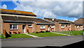
St David's Close bungalows, Llanelli
On the east side of St David's Close, viewed across Glanmor Road.
Image: © Jaggery
Taken: 15 Aug 2015
0.03 miles
3
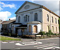
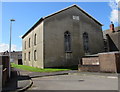
Former Siloah chapel, Llanelli
On the corner of Copperworks Road and Glanmor Road viewed in mid August 2015 when all ground floor windows are boarded over. The oval inscription records that Siloah Independent Chapel was built in 1840, enlarged in 1855.
Image: © Jaggery
Taken: 15 Aug 2015
0.03 miles
4
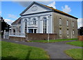
Bethel Baptist Chapel, Llanelli
Located between Glanmor Road and Marine Street, at the edge of St David's Close.
The oval tablet records that this is the 1850 enlargement of the 1840 original.
Image: © Jaggery
Taken: 15 Aug 2015
0.03 miles
5
North side of Bethel Baptist Chapel, Llanelli
Viewed from St David's Close. The chapel's best side is its south. http://www.geograph.org.uk/photo/4615816
Image: © Jaggery
Taken: 15 Aug 2015
0.03 miles
6
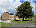
Tree and houses, St David's Close, Llanelli
Viewed across Glanmor Road.
Image: © Jaggery
Taken: 15 Aug 2015
0.04 miles
7
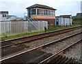
Llanelli West signal box
Known as Llanelli West Ground Frame, the box controls the barriers at two level crossings,
one each end of Llanelli railway station. It is located just beyond the western edge
of the station, adjacent to the Glanmor Road level crossing.
Image: © Jaggery
Taken: 8 Apr 2012
0.04 miles
8
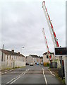
Glanmor Road level crossing, Llanelli
Looking south along Glanmor Road across the level crossing at the western edge of Llanelli railway station.
Image: © Jaggery
Taken: 8 Apr 2012
0.04 miles
9
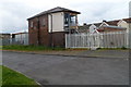
Back view of Llanelli West Ground Frame
Viewed across Clos Glanmor. Originally a signal box, this is now a ground frame used to control the barriers at two level crossing, one at each end of Llanelli railway station. The two windows on this side of the building have been bricked up. http://www.geograph.org.uk/photo/2890787 to a front view.
Image: © Jaggery
Taken: 8 Apr 2012
0.04 miles
10
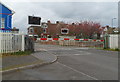
Barriers down, Glanmor Road level crossing, Llanelli
A westbound train has just arrived at Llanelli railway station, on the east (right) side of the level crossing. The barriers are down and the red lights are flashing in readiness for the passage of the train http://www.geograph.org.uk/photo/2890885 across the road in a couple of minutes.
Once Upon a Time Day Nursery http://www.geograph.org.uk/photo/2890755 is on the left.
Image: © Jaggery
Taken: 8 Apr 2012
0.04 miles