IMAGES TAKEN NEAR TO
Granby Close, LLANELLI, SA15 2ED
Introduction
This page details the photographs taken nearby to Granby Close, SA15 2ED by members of the Geograph project.
The Geograph project started in 2005 with the aim of publishing, organising and preserving representative images for every square kilometre of Great Britain, Ireland and the Isle of Man.

There are currently over 7.5m images from over14,400 individuals and you can help contribute to the project by visiting https://www.geograph.org.uk
Image Map (Loading...)


Getting Data...Please wait
Leaflet Map data © OpenStreetMap
Images are licensed for reuse under creativecommons.org/licenses/by-sa/2.0
Notes
- Clicking on the map will re-center to the selected point.
- The higher the marker number, the further away the image location is from the centre of the postcode.
Image Listing (30 Images Found)
Images are licensed for reuse under creativecommons.org/licenses/by-sa/2.0
Image
Details
Distance
1
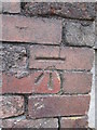
Ordnance Survey Cut Mark
This OS cut mark can be found on the wall to the east of Embankment Road. It marks a point 6.7879m above mean sea level.
Image: © Adrian Dust
Taken: 20 Jul 2014
0.03 miles
2
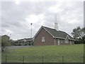
Mormon Chapel, Llanelli
Llanelli has played an important part in the Church of Jesus Christ and the Latter Day Saints' history in Wales being the second centre to open in the principality. The first chapel was built in the centre of the town in 1849 - the first Mormon chapel built in the United Kingdom.
This modern more recent building replaces the original building.
Image: © Hywel Williams
Taken: 4 Oct 2006
0.05 miles
3
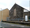
Morfa Social Club, Llanelli
The club is on the north side of New Street, opposite Christ Church. http://www.geograph.org.uk/photo/2893468
Image: © Jaggery
Taken: 8 Apr 2012
0.06 miles
4
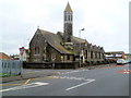
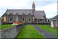
Christ Church, Morfa, Llanelli viewed from the NE
The Church in Wales church is located on the south side of New Street in the Morfa district of Llanelli.
A plaque on the building shows
CHRIST CHURCH
ERECTED 1887
CONSECRATED ON 14TH OCTOBER 1887.
This view is across New Street. http://www.geograph.org.uk/photo/2893454 to a view from the south.
Image: © Jaggery
Taken: 8 Apr 2012
0.06 miles
5
Christ Church, Morfa, Llanelli viewed from the south
The Church in Wales church is located on the south side of New Street in the Morfa district of Llanelli.
A plaque on the building shows
CHRIST CHURCH
ERECTED 1887
CONSECRATED ON 14TH OCTOBER 1887.
http://www.geograph.org.uk/photo/2893468 to a view from the NE
Image: © Jaggery
Taken: 8 Apr 2012
0.06 miles
6
Mormon church, Llanelli
The church is set back from Embankment Road. The Mormons refer to themselves as members of The Church of Jesus Christ of Latter Day Saints.
Image: © Jaggery
Taken: 8 Apr 2012
0.08 miles
7
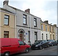
Former Tregoning Library, Llanelli
A blue plaque http://www.geograph.org.uk/photo/2894226 on the wall of the Cornish Place house records that, from 1872 to 1936,
the building housed the library set up for the workers of the Morfa Works.
Image: © Jaggery
Taken: 8 Apr 2012
0.13 miles
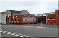
8
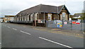
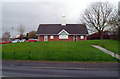
Former Morfa Infants School, Llanelli
Viewed across New Road. The building is now used by Flying Start, a Welsh Assembly Government funded programme, which provides support services for children younger than 4 and their families living in areas of disadvantage in Carmarthenshire.
Image: © Jaggery
Taken: 8 Apr 2012
0.13 miles
9
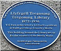
Tregoning Library blue plaque, Llanelli
The Llanelli Community Heritage plaque is on the wall of a Cornish Place house. http://www.geograph.org.uk/photo/2894219
Image: © Jaggery
Taken: 8 Apr 2012
0.13 miles
10
Wesleyan Community Centre, Llanelli
Located in Campbell Street in the Morfa district of Llanelli.
Image: © Jaggery
Taken: 8 Apr 2012
0.14 miles