IMAGES TAKEN NEAR TO
Bowen Terrace, LLANELLI, SA15 2AR
Introduction
This page details the photographs taken nearby to Bowen Terrace, SA15 2AR by members of the Geograph project.
The Geograph project started in 2005 with the aim of publishing, organising and preserving representative images for every square kilometre of Great Britain, Ireland and the Isle of Man.

There are currently over 7.5m images from over14,400 individuals and you can help contribute to the project by visiting https://www.geograph.org.uk
Image Map (Loading...)


Getting Data...Please wait
Leaflet Map data © OpenStreetMap
Images are licensed for reuse under creativecommons.org/licenses/by-sa/2.0
Notes
- Clicking on the map will re-center to the selected point.
- The higher the marker number, the further away the image location is from the centre of the postcode.
Image Listing (18 Images Found)
Images are licensed for reuse under creativecommons.org/licenses/by-sa/2.0
Image
Details
Distance
1
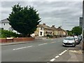
Lower Trostre Road
Housing in Lower Trostre Road.
Image: © Alan Hughes
Taken: 26 Jun 2019
0.12 miles
2
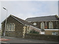
Wesleyan Community Centre, Llanelli
Located in Campbell Street in the Morfa district of Llanelli.
Image: © Jaggery
Taken: 8 Apr 2012
0.16 miles
3
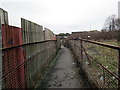
Llwybr Heol Ropewalk / Ropewalk Road Path
Llwybr cyhoeddus yn agosau at Heol Ropewalk.
A public footpath approaching Ropewalk Road.
Image: © Alan Richards
Taken: 30 Jan 2018
0.17 miles
4

Footbridge over the West Wales railway line
With a children's park and several public footpaths converging nearby, you get the impression they REALLY don't want people trespassing on the railway line around here.
Image: © Hywel Williams
Taken: 10 Mar 2007
0.17 miles
5
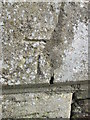
Ordnance Survey Cut Mark
This OS cut mark can be found on the front of Bethania Chapel, Dafen Row. It marks a point 6.0198m above mean sea level. http://www.geograph.org.uk/photo/4080043
Image: © Adrian Dust
Taken: 20 Jul 2014
0.20 miles
6
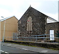
Bethania Baptist Chapel
There is an Ordnance Survey cut mark on the south angle. http://www.geograph.org.uk/photo/4080042
Image: © Adrian Dust
Taken: 20 Jul 2014
0.20 miles
7
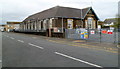
Former Morfa Infants School, Llanelli
Viewed across New Road. The building is now used by Flying Start, a Welsh Assembly Government funded programme, which provides support services for children younger than 4 and their families living in areas of disadvantage in Carmarthenshire.
Image: © Jaggery
Taken: 8 Apr 2012
0.20 miles
8
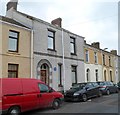
Former Tregoning Library, Llanelli
A blue plaque http://www.geograph.org.uk/photo/2894226 on the wall of the Cornish Place house records that, from 1872 to 1936,
the building housed the library set up for the workers of the Morfa Works.
Image: © Jaggery
Taken: 8 Apr 2012
0.20 miles
9
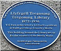
Tregoning Library blue plaque, Llanelli
The Llanelli Community Heritage plaque is on the wall of a Cornish Place house. http://www.geograph.org.uk/photo/2894219
Image: © Jaggery
Taken: 8 Apr 2012
0.20 miles
10
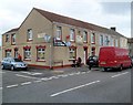
Golfers Inn, Llanelli
Pub in the Morfa district of Llanelli, on the corner of Cornish Place and Glandafen Road. Some sources state that the pub is on Dafen Row, but the street name sign at the corner of the pub shows Glandafen Road.
Image: © Jaggery
Taken: 8 Apr 2012
0.21 miles