1
King George V postbox in the wall of Ann Street Post Office, Llanelli
Located on the left here. http://www.geograph.org.uk/photo/4870137
The GR on the box is short for Georgius Rex, Latin for King George,
in this case King George V who reigned from May 1910-January 1936.
The inscription on the bottom of the box is W.T.ALLEN & CO LONDON.
Image: © Jaggery
Taken: 10 Mar 2016
0.03 miles
2
Post Office
Ann Street Post Office, Llanelli.
Image: © Alan Hughes
Taken: 7 Sep 2018
0.03 miles
3
Ann Street Post Office, Llanelli
Two-counter post office and small shop at 18 Ann Street.
Image: © Jaggery
Taken: 10 Mar 2016
0.04 miles
4
Down Prendergast Street
Running parallel with Bigyn Hill. Numbers 8 to 14 visible on the left. Stradey Woods visible in the far distance.
The name Prendergast is Flemish in origin and is believed to come from the 'lost' Norman/Flemish village of Brontegeest. It came to Britain with a follower of Duke William after the conquest who was given lands near Haverfordwest.
Image: © Deborah Tilley
Taken: 8 Dec 2008
0.04 miles
5
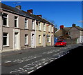
Ann Street houses, Llanelli
On the west side of the street, near Ann Street Post Office http://www.geograph.org.uk/photo/4870137 out of shot on the left.
Image: © Jaggery
Taken: 10 Mar 2016
0.05 miles
6
Overgrown south side of Grade II listed Calvaria Baptist Chapel, Llanelli
Viewed in March 2016. http://www.geograph.org.uk/photo/4870506 to the north side of the Grade II listed building.
Image: © Jaggery
Taken: 10 Mar 2016
0.05 miles
7
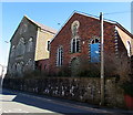
Derelict buildings, Ann Street, Llanelli
The year 1881 is inscribed in the roundel on the building on the right, perhaps a former Sunday School.
Grade II listed Calvaria Baptist Chapel http://www.geograph.org.uk/photo/4870506 is on the left, on the corner of Bigyn Road.
Image: © Jaggery
Taken: 10 Mar 2016
0.05 miles
8
Calvaria Baptist Chapel
There is an OS cut mark on the NE angle of the chapel. http://www.geograph.org.uk/photo/4080082
Image: © Adrian Dust
Taken: 20 Jul 2014
0.06 miles
9
Ordnance Survey Cut Mark
This OS cut mark can be found on the NW face, NE angle of the Calvaria Baptist Chapel. http://www.geograph.org.uk/photo/4080083
Image: © Adrian Dust
Taken: 20 Jul 2014
0.06 miles
10
Grade II listed Calvaria Baptist Chapel, Llanelli
The building on the corner of Bigyn Road and Ann Street looks derelict in March 2016. The only name to be seen is CALVARIA BAPTIST CHAPEL engraved in stone above the Ann Street doors. Erected in 1887-1888, the building was Grade II listed in 1992.
Image: © Jaggery
Taken: 10 Mar 2016
0.06 miles


