IMAGES TAKEN NEAR TO
Wern Road, LLANELLI, SA15 1SR
Introduction
This page details the photographs taken nearby to Wern Road, SA15 1SR by members of the Geograph project.
The Geograph project started in 2005 with the aim of publishing, organising and preserving representative images for every square kilometre of Great Britain, Ireland and the Isle of Man.

There are currently over 7.5m images from over14,400 individuals and you can help contribute to the project by visiting https://www.geograph.org.uk
Image Map
Images are licensed for reuse under creativecommons.org/licenses/by-sa/2.0
Notes
- Clicking on the map will re-center to the selected point.
- The higher the marker number, the further away the image location is from the centre of the postcode.
Image Listing (95 Images Found)
Images are licensed for reuse under creativecommons.org/licenses/by-sa/2.0
Image
Details
Distance
1
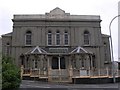
Capel Als, Marble Hall Road, Llanelli.
Capel Als, Marble Hall Road. Off to the left in the photograph is Wern Street, whilst Als Street runs to the right of the building.
Image: © Gary Davies
Taken: 27 Jul 2004
0.04 miles
2
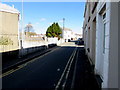
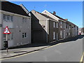
No parking on Tunnel Road, Llanelli
Double yellow lines on both sides indicate no parking at any time.
Image: © Jaggery
Taken: 10 Mar 2016
0.06 miles
3

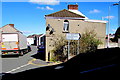
Turn right here for Elim Pentecostal Church and Myrtle House, Llanelli
The direction sign on the corner of Tunnel Road points towards Myrtle Terrace. http://www.geograph.org.uk/photo/4890401
Image: © Jaggery
Taken: 10 Mar 2016
0.06 miles
4
This way to Elim Pentecostal Church and Myrtle House, Llanelli
The black arrow on the sign on the corner of Wern Road points right along Tunnel Road.
Image: © Jaggery
Taken: 10 Mar 2016
0.07 miles
5
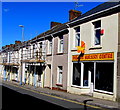
Discount Nursery Centre, Llanelli
Shop at 73 Pottery Street.
Image: © Jaggery
Taken: 10 Mar 2016
0.08 miles
6
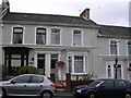
Victorian terrace houses, Llanelli
College Hill.
Image: © Gary Davies
Taken: 27 Jul 2004
0.08 miles
7
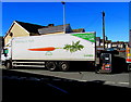
We're big on fresh, Wern Road, Llanelli
The Londis lorry has brought new stock for the nearby Londis convenience store http://www.geograph.org.uk/photo/4866561
Image: © Jaggery
Taken: 10 Mar 2016
0.08 miles
8
Warning sign - roundabout ahead, Pottery Street, Llanelli
The sign is on the corner of Elizabeth Street and Pottery Street
on the approach to the roundabout at the Upper Robinson Street junction.
Image: © Jaggery
Taken: 10 Mar 2016
0.08 miles
9
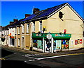
Londis on a Llanelli corner
Convenience store on the corner of Pottery Street and Wern Road,
viewed from the corner of Ann Street and Bigyn Road.
Image: © Jaggery
Taken: 10 Mar 2016
0.09 miles
10
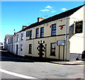
Vale of Neath pub, Llanelli
Pub at 2 Tunnel Road, on the corner of Bigyn Road.
Image: © Jaggery
Taken: 10 Mar 2016
0.09 miles