IMAGES TAKEN NEAR TO
Inkerman Street, LLANELLI, SA15 1SA
Introduction
This page details the photographs taken nearby to Inkerman Street, SA15 1SA by members of the Geograph project.
The Geograph project started in 2005 with the aim of publishing, organising and preserving representative images for every square kilometre of Great Britain, Ireland and the Isle of Man.

There are currently over 7.5m images from over14,400 individuals and you can help contribute to the project by visiting https://www.geograph.org.uk
Image Map (Loading...)


Getting Data...Please wait
Leaflet Map data © OpenStreetMap
Images are licensed for reuse under creativecommons.org/licenses/by-sa/2.0
Notes
- Clicking on the map will re-center to the selected point.
- The higher the marker number, the further away the image location is from the centre of the postcode.
Image Listing (122 Images Found)
Images are licensed for reuse under creativecommons.org/licenses/by-sa/2.0
Image
Details
Distance
1
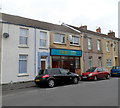
Thomas Stained Glass, Llanelli
Glass supplier in Inkerman Street.
Image: © Jaggery
Taken: 8 Apr 2012
0.01 miles
2
Church building
One of the several churches in Llanelli that have fallen into disuse over the years and are now being used for different purposes. This church now contains a furniture warehouse. The organ and pulpit are still in place, but where once there were pews there are now settees and sofas - a curious sight indeed.
Image: © Hywel Williams
Taken: 26 Oct 2006
0.02 miles
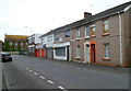
3
First Cymru bus depot and yard, Llanelli
On the corner of Inkerman Street and Ralph Street.
Image: © Jaggery
Taken: 8 Apr 2012
0.03 miles
4
Inkerman Street, Llanelli
Looking ENE towards Ebenezer Chapel. http://www.geograph.org.uk/photo/3634600
Image: © Jaggery
Taken: 8 Apr 2012
0.04 miles
5
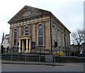
Greenfield Baptist Chapel, Llanelli
On the corner of Station Road and Murray Street. The large name tablet in the pediment shows the year 1858. Llanelli by the mid 1850s was developing both industrially and as a thriving port. There had been an influx of English-speaking families, mainly from the west of England, looking for work in the town's iron, steel and shipping industries. This church was built to meet their wishes to worship in English in a town where existing chapels held services in Welsh.
Image: © Jaggery
Taken: 8 Apr 2012
0.04 miles
6
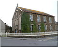
Ebenezer Chapel, Llanelli
On the corner of Ralph Street and Inkerman Street. A faded date stone shows the year 1881.
Image: © Jaggery
Taken: 8 Apr 2012
0.04 miles
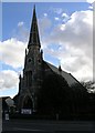
7
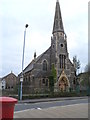
Former Park Street English Congregational Church, Llanelli
In a mainly Welsh-speaking town, the first English language Congregational Church in Llanelli was built in 1839 in Park Street. When the need arose to enlarge and modernise the church building, the original intent was to rebuild on the Park Street site. This proved to be unworkable, so a new site was found,
here on the corner of Inkerman Street and Murray Street.
The church in view, retaining the name of its predecessor, opened in October 1865. From 1972 the church was part of the United Reformed Church. At the April 2012 date of this view, there were no name signs to be seen, and the building appeared derelict.
Image: © Jaggery
Taken: 8 Apr 2012
0.05 miles
8
Stepney Street (Recreated)
This is a recreation of the following 1957 picture from the Frith collection: http://www.francisfrith.com/search/wales/dyfed/llanelli/photos/llanelli_L73056.htm
The left hand side of the picture is definitely recognisable right down to the white square which has an advertisement on the 1957 picture. The right hand side of the picture is an entirely different story. I can remember this entire street being demolished when I was younger and a small park being put in its place which included a rather stark sunken garden. This sunken garden is currently being demolished by the council (or their subcontractors) - who knows what'll appear there next?
Image: © Hywel Williams
Taken: 10 Jan 2007
0.05 miles
9
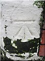
Ordnance Survey Cut Mark
This OS cut mark can be found on Castle Buildings, at the junction of Station Road & Murray Street. Now the Vista Lounge. It marks a point 8.2418m above mean sea level.
Image: © Adrian Dust
Taken: 8 Feb 2014
0.05 miles
10
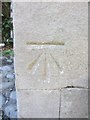
Ordnance Survey Cut Mark
This Ordnance Survey Cut Mark can be found adjacent to the entrance to the Parc Congregational Church. On the 1880 Town Plans the height above sea level of this mark is given as 28.2ft.
Image: © Adrian Dust
Taken: 26 May 2013
0.05 miles