IMAGES TAKEN NEAR TO
Charles Street, LLANELLI, SA15 1LZ
Introduction
This page details the photographs taken nearby to Charles Street, SA15 1LZ by members of the Geograph project.
The Geograph project started in 2005 with the aim of publishing, organising and preserving representative images for every square kilometre of Great Britain, Ireland and the Isle of Man.

There are currently over 7.5m images from over14,400 individuals and you can help contribute to the project by visiting https://www.geograph.org.uk
Image Map (Loading...)


Getting Data...Please wait
Leaflet Map data © OpenStreetMap
Images are licensed for reuse under creativecommons.org/licenses/by-sa/2.0
Notes
- Clicking on the map will re-center to the selected point.
- The higher the marker number, the further away the image location is from the centre of the postcode.
Image Listing (45 Images Found)
Images are licensed for reuse under creativecommons.org/licenses/by-sa/2.0
Image
Details
Distance
1
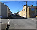
Crossroads in suburban Llanelli
From Penywarc Road to Charles Street past Lower Cross Road on the left and Upper Cross Road on the right.
Image: © Jaggery
Taken: 10 Mar 2016
0.01 miles
2
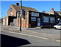
Eastern Eye, Llanelli
Indian takeaway on the east side of the South Star, http://www.geograph.org.uk/photo/5067403 viewed across Charles Street.
Image: © Jaggery
Taken: 10 Mar 2016
0.02 miles
3
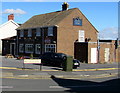
South Star, Llanelli
Pub and bistro at 2 Brynallt Terrace, on the corner of Charles Street.
Image: © Jaggery
Taken: 10 Mar 2016
0.03 miles
4
Junction of Charles Street and Brynallt Terrace, Llanelli
Viewed from Charles Street looking across Brynallt Terrace towards
Stebonheath Primary School (Ysgol Gynradd Stebonheath in Welsh).
Image: © Jaggery
Taken: 10 Mar 2016
0.05 miles
5
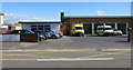
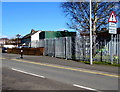
Llanelli Ambulance Station
Viewed across the road named Heol Elli.
Image: © Jaggery
Taken: 10 Mar 2016
0.05 miles
6
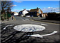
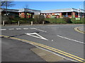
Mini-roundabout in the middle of a 3-way junction, Llanelli
In the middle of the junctions of Marble Hall Road, Heol Elli and Brynallt Terrace (ahead).
Image: © Jaggery
Taken: 10 Mar 2016
0.06 miles
7
Wires over Upper Cross Road, Llanelli
Upper Cross Road (Heol y Groes Uchaf in Welsh) is on the north side of Charles Street.
Image: © Jaggery
Taken: 10 Mar 2016
0.06 miles
8
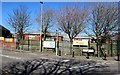
Tree-lined southern perimeter of Stebonheath Primary School, Llanelli
Viewed across Marble Hall Road. Stebonheath Primary School is Ysgol Gynradd Stebonheath in Welsh.
Image: © Jaggery
Taken: 10 Mar 2016
0.06 miles
9
Warning sign - ambulance station, Heol Elli, Llanelli
On the approach to this http://www.geograph.org.uk/photo/5067384 ambulance station (gorsaf ambiwlans in Welsh).
Image: © Jaggery
Taken: 10 Mar 2016
0.08 miles
10
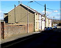
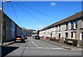
Penywarc Road houses, Llanelli
Penywarc Road is a dead-end road on the east side of Charles Street.
Image: © Jaggery
Taken: 10 Mar 2016
0.09 miles