1
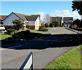
Y Clos, Coed Cae, Llanelli
Viewed across Coed Cae Road. Y Clos leads to the residential street named Ridgewood Park.
Image: © Jaggery
Taken: 10 Mar 2016
0.01 miles
2
Coed Cae Road bungalows, Llanelli
Opposite Nightingale Court.
Image: © Jaggery
Taken: 10 Mar 2016
0.05 miles
3
Dormer bungalows, Coed Cae Road, Llanelli
The dormer is the window projecting from the roof.
Image: © Jaggery
Taken: 10 Mar 2016
0.05 miles
4
Coed Cae Road speed bumps, Llanelli
From this walker's viewpoint, the bumps look inconsequential, in contrast to,
for example, the speed bumps http://www.geograph.org.uk/photo/4764203 across Stonehouse High Street.
Image: © Jaggery
Taken: 10 Mar 2016
0.06 miles
5
Bilingual name sign - Nightingale Court/Cwrt-yr-Eos, Llanelli
Viewed from the corner of Coed Cae Road.
Most of the street name signs I saw in Llanelli today are in both English and Welsh, as here.
Image: © Jaggery
Taken: 10 Mar 2016
0.06 miles
6
Coed Cae Road bungalows, Llanelli
Located near the Glyncoed Terrace junction.
Image: © Jaggery
Taken: 10 Mar 2016
0.06 miles
7
Ildiwch 50 llath/Give Way 50 yards, Coed Cae Road, Llanelli
The bilingual (Welsh/English) warning sign is on the approach to the Glyncoed Terrace junction.
Image: © Jaggery
Taken: 10 Mar 2016
0.08 miles
8
Coed Cae Road semis, Llanelli
Semi-detached houses northeast of Zammit Crescent. http://www.geograph.org.uk/photo/4858318
Image: © Jaggery
Taken: 10 Mar 2016
0.09 miles
9
Nightingale Court, Llanelli
From the corner of Coed Cae Road. Nightingale Court leads to Kingfisher Court, the left turn in the distance.
Image: © Jaggery
Taken: 10 Mar 2016
0.09 miles
10
KFC advert on a BT phonebox, Coed Cae Road, Llanelli
Originally named Kentucky Fried Chicken, KFC is the second largest
restaurant chain in the world (in terms of sales), after McDonald's.
Image: © Jaggery
Taken: 10 Mar 2016
0.10 miles


