IMAGES TAKEN NEAR TO
James Street, LLANELLI, SA15 1DY
Introduction
This page details the photographs taken nearby to James Street, SA15 1DY by members of the Geograph project.
The Geograph project started in 2005 with the aim of publishing, organising and preserving representative images for every square kilometre of Great Britain, Ireland and the Isle of Man.

There are currently over 7.5m images from over14,400 individuals and you can help contribute to the project by visiting https://www.geograph.org.uk
Image Map
Images are licensed for reuse under creativecommons.org/licenses/by-sa/2.0
Notes
- Clicking on the map will re-center to the selected point.
- The higher the marker number, the further away the image location is from the centre of the postcode.
Image Listing (23 Images Found)
Images are licensed for reuse under creativecommons.org/licenses/by-sa/2.0
Image
Details
Distance
1
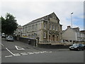
Glenalla Methodist Chapel
There is an Ordnance Survey cut mark on a wall post of the chapel. http://www.geograph.org.uk/photo/4080086
Image: © Adrian Dust
Taken: 20 Jul 2014
0.08 miles
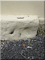
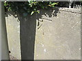
2
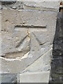
Ordnance Survey Cut Mark
This OS cut mark can be found on a post in the wall of the Glenalla Methodist Chapel. It marks a point 18.980m above mean sea level. http://www.geograph.org.uk/photo/4080091
Image: © Adrian Dust
Taken: 20 Jul 2014
0.08 miles
3
Ordnance Survey Cut Mark
This OS cut mark can be found on the Old Nurses Home on Palace Avenue. It marks a point 33.674m above mean sea level. http://www.geograph.org.uk/photo/4080076
Image: © Adrian Dust
Taken: 20 Jul 2014
0.08 miles
4
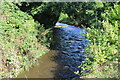
Afon Lleidi near Andrew Street
Looking upstream from footpath at the northern end of Andrew Street.
Image: © M J Roscoe
Taken: 1 Oct 2021
0.13 miles
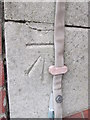
5
Ordnance Survey Pivot
This heavily painted OS pivot can be found on No29 Marblehall Road. It marks a point 17.877m above mean sea level.
Image: © Adrian Dust
Taken: 20 Jul 2014
0.18 miles
6
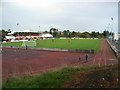
Stebonheath Park
The ground of Llanelli AFC. The far end of the main stand, with the curved white roof, houses the Jock Stein Suite, named after the former Scotland manager, who was a professional player here in the 1950's.
Image: © David Luther Thomas
Taken: 21 Oct 2006
0.19 miles
7
Island House public house
The Island House pub as it was in 2007. At this time it was one of the only buildings left in an area scheduled for development. It has since been demolished to make way for a new cinema and entertainment centre.
Image: © Hywel Williams
Taken: 24 Apr 2007
0.20 miles
8
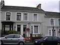
Victorian terrace houses, Llanelli
College Hill.
Image: © Gary Davies
Taken: 27 Jul 2004
0.20 miles
9
Ordnance Survey Cut Mark
This OS cut mark can be found on the wall of No55 Cilgant Lliedi. It marks a point 16.849m above mean sea level.
Image: © Adrian Dust
Taken: 17 Aug 2014
0.23 miles
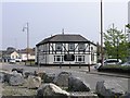
10
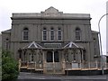
Capel Als, Marble Hall Road, Llanelli.
Capel Als, Marble Hall Road. Off to the left in the photograph is Wern Street, whilst Als Street runs to the right of the building.
Image: © Gary Davies
Taken: 27 Jul 2004
0.23 miles