IMAGES TAKEN NEAR TO
Langland Mews, LLANELLI, SA15 1AX
Introduction
This page details the photographs taken nearby to Langland Mews, SA15 1AX by members of the Geograph project.
The Geograph project started in 2005 with the aim of publishing, organising and preserving representative images for every square kilometre of Great Britain, Ireland and the Isle of Man.

There are currently over 7.5m images from over14,400 individuals and you can help contribute to the project by visiting https://www.geograph.org.uk
Image Map
Images are licensed for reuse under creativecommons.org/licenses/by-sa/2.0
Notes
- Clicking on the map will re-center to the selected point.
- The higher the marker number, the further away the image location is from the centre of the postcode.
Image Listing (133 Images Found)
Images are licensed for reuse under creativecommons.org/licenses/by-sa/2.0
Image
Details
Distance
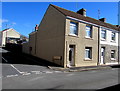
1
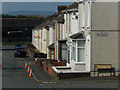
Fron Terrace, Llanelli
Fron Terrace is a continuation of Tyisha Road heading down the hill below Dillwyn Street. In the distance are the hills of the Gower.
Image: © Stephen McKay
Taken: 4 Jun 2018
0.03 miles
2
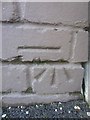
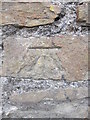
Ordnance Survey Cut Mark
This OS cut mark can be found on the wall of No41 Fron Terrace. It marks a point 11.817m above mean sea level.
Image: © Adrian Dust
Taken: 27 Feb 2014
0.04 miles
3
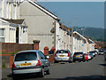
Dillwyn Street, Llanelli
Looking along Dillwyn Street from close to the junction with Tyisha Road/Fron Terrace.
Image: © Stephen McKay
Taken: 4 Jun 2018
0.07 miles
4
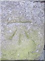
Ordnance Survey Cut Mark
This OS cut mark can be found on the Railway Goods Shed. It marks a point 6.794m above mean sea level.
Image: © Adrian Dust
Taken: 27 Feb 2014
0.08 miles
5
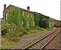
Former railway goods depot, Llanelli
Image: © Roger Cornfoot
Taken: 21 Aug 2017
0.08 miles
6
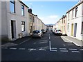
Rice Street, Llanelli
Descending from Margam Place to Mansel Place.
Image: © Jaggery
Taken: 10 Mar 2016
0.10 miles
7
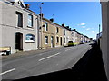
Sunny side of Llewellyn Street, Llanelli
Viewed from the corner of Emma Street.
Image: © Jaggery
Taken: 10 Mar 2016
0.11 miles
8
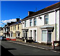
Tyisha Road houses, Llanelli
Southwest of the Margam Place junction.
Image: © Jaggery
Taken: 10 Mar 2016
0.11 miles
9
Ordnance Survey Cut Mark
This OS cut mark can be found on the wall to the north of Trinity Road. It marks a point 5.3614m above mean sea level.
Image: © Adrian Dust
Taken: 20 Jul 2014
0.11 miles
10
Corner of Dillwyn Street and Christopher Street, Llanelli
A postbox http://www.geograph.org.uk/photo/4858247 is in shadow on the east side of Christopher Street.
Image: © Jaggery
Taken: 10 Mar 2016
0.12 miles