1
Henrietta Street, Swansea
Viewed from the Walter Road end looking towards St Helen's Road.
Image: © Jaggery
Taken: 27 Apr 2014
0.02 miles
2
Ordnance Survey Cut Mark
This OS cut mark can be found on the wall of No10 George Street. It marks a point 16.066m above mean sea level.
Image: © Adrian Dust
Taken: 19 Nov 2013
0.03 miles
3
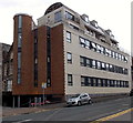
154-155 St Helens Road, Swansea
This is the Henrietta Street side of an apartment block at 154-155 St Helens Road.
Image: © Jaggery
Taken: 27 Apr 2014
0.04 miles
4
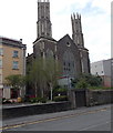
Ebenezer Newydd chapel, Swansea
Viewed across Henrietta Street. Ebenezer Newydd was previously a Welsh Congregational chapel.
The inscription in stone above the twin doors is
HENRIETTA WELSH CONGREGATIONAL CHAPEL BUILT AD 1896.
Image: © Jaggery
Taken: 27 Apr 2014
0.04 miles
5
Ordnance Survey Cut Mark
This OS cut mark can be found on the wall of No8 Russell Street. It marks a point 14.649m above mean sea level.
Image: © Adrian Dust
Taken: 19 Nov 2013
0.05 miles
6
Zac's Place, Swansea
The former Gospel Hall in George Street is now owned and run by Exousia Trust. It is a multipurpose venue used for the Trust's work, primarily Zac's Place - "A Church For Ragamuffins".
Image: © Jaggery
Taken: 27 Apr 2014
0.05 miles
7
Russell Street Swansea
From the corner of Duke Street.
Image: © Jaggery
Taken: 27 Apr 2014
0.05 miles
8
Morse and Valerio, Swansea
The board on the Henrietta Street office shows John Morse Solicitors incorporating Michelle Valerio.
Image: © Jaggery
Taken: 27 Apr 2014
0.06 miles
9
Swan Gardens, St Helen's Road, Swansea
Swan House at 157-159 St Helen's Road contains 31 flats built in 2003. Its name on the right side of the building is shown in English and also in Chinese characters. There is a non-resident management staff and community alarm service. This is housing with support intended primarily for older people of Chinese origin. Regular social activities include close links with the Chinese community co-operative centre. There is a purpose designed kitchen for preparing Chinese meals. New residents are accepted from 55 years of age.
Image: © Jaggery
Taken: 27 Apr 2014
0.06 miles
10
Distinctive twin towers, St Helen's Road, Swansea
Built in 1862 as St Andrew's Methodist Chapel. After fire damage in the mid 20th century, the building was renovated, and reopened in 1964. In the early 21st century it was in use as a mosque and Islamic Centre. Its use, if any, was unclear at the late April 2014 date of this view.
There were no name signs to be seen, and part of the building was encased in scaffolding. http://www.geograph.org.uk/photo/4025860
Image: © Jaggery
Taken: 27 Apr 2014
0.06 miles


