IMAGES TAKEN NEAR TO
Christina Street, SWANSEA, SA1 4ES
Introduction
This page details the photographs taken nearby to Christina Street, SA1 4ES by members of the Geograph project.
The Geograph project started in 2005 with the aim of publishing, organising and preserving representative images for every square kilometre of Great Britain, Ireland and the Isle of Man.

There are currently over 7.5m images from over14,400 individuals and you can help contribute to the project by visiting https://www.geograph.org.uk
Image Map
Images are licensed for reuse under creativecommons.org/licenses/by-sa/2.0
Notes
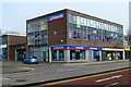
- Clicking on the map will re-center to the selected point.
- The higher the marker number, the further away the image location is from the centre of the postcode.
Image Listing (171 Images Found)
Images are licensed for reuse under creativecommons.org/licenses/by-sa/2.0
Image
Details
Distance
1
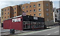
Nawab, Swansea
Indian cuisine restaurant & takeaway in Christina Street, near the corner of The Kingsway.
Image: © Jaggery
Taken: 27 Apr 2014
0.04 miles
2
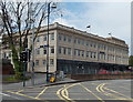
Tŷ Gwalia, Swansea
Tŷ Gwalia, 7-13 The Kingsway, is the Swansea office of Grŵp Gwalia Cyf, a major provider of social housing and care services in south and mid Wales. Gwalia manages more than 10,000 units of accommodation.
Image: © Jaggery
Taken: 27 Apr 2014
0.06 miles
3
Tŷ Gwalia, Swansea
Tŷ Gwalia, 7-13 The Kingsway, is the Swansea office of Grŵp Gwalia Cyf, a major provider of social housing and care services in south and mid Wales. Gwalia manages more than 10,000 units of accommodation.
Image: © Jaggery
Taken: 11 Mar 2012
0.07 miles
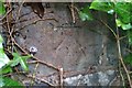
4
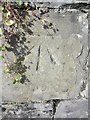
Ordnance Survey Cut Mark
This OS cut mark can be found on the wall of No55 Mansel Street. It marks a point 22.793m above mean sea level.
Image: © Adrian Dust
Taken: 29 Oct 2013
0.08 miles
5
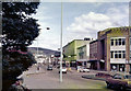
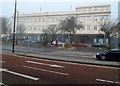
The Kingsway, Swansea
View down Kingsway from outside the YMCA. The Odeon cinema and Top Rank Suite can be seen in the middle distance and Kilvey Hill rises up in the background. This was taken on a Sunday if my memory serves me right so note the lack of traffic. Shops were still closed on Sundays in 1979.
Image: © Brian Whittle
Taken: 6 May 1979
0.08 miles
6
Vacant former Koopas bar and club premises, The Kingsway, Swansea
Viewed in April 2014. A local newspaper reported in January 2013 that Koopas
had lost its licence after it failed to comply with safety and security regulations.
Image: © Jaggery
Taken: 27 Apr 2014
0.08 miles
7
Ordnance Survey Cut Mark
This OS cut mark can be found on the wall NW side of Carlton Terrace. It marks a point 27.5478m above mean sea level.
Image: © Adrian Dust
Taken: 5 Dec 2018
0.09 miles
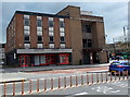
8
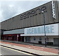
Icehouse, Oceana, Swansea
Viewed across The Kingsway. Oceana is a UK chain of nightclubs, multi-room venues with each room themed on a different city, each with a different music style. Icehouse is themed on Reykjavik, Iceland.
Image: © Jaggery
Taken: 27 Apr 2014
0.09 miles
9
Nationwide, The Kingsway, Swansea
Building society branch, New Oxford House, The Kingsway.
Nationwide was the biggest UK building society that did not convert to a bank in the so-called demutualisations in the decade from the late 1980s. It is now bigger than all the other remaining UK building societies combined.
Image: © Jaggery
Taken: 11 Mar 2012
0.09 miles
10
Northampton Lane side of the YMCA building, Swansea
Viewed across Page Street. Northampton Lane is on the left. The name inscribed above the doorway behind the cars is LLEWELYN HALL. http://www.geograph.org.uk/photo/4025986 to a front view of the YMCA building.
Image: © Jaggery
Taken: 27 Apr 2014
0.10 miles