IMAGES TAKEN NEAR TO
St. Helens Road, SWANSEA, SA1 4AZ
Introduction
This page details the photographs taken nearby to St. Helens Road, SA1 4AZ by members of the Geograph project.
The Geograph project started in 2005 with the aim of publishing, organising and preserving representative images for every square kilometre of Great Britain, Ireland and the Isle of Man.

There are currently over 7.5m images from over14,400 individuals and you can help contribute to the project by visiting https://www.geograph.org.uk
Image Map
Images are licensed for reuse under creativecommons.org/licenses/by-sa/2.0
Notes
- Clicking on the map will re-center to the selected point.
- The higher the marker number, the further away the image location is from the centre of the postcode.
Image Listing (114 Images Found)
Images are licensed for reuse under creativecommons.org/licenses/by-sa/2.0
Image
Details
Distance
1
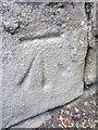
Ordnance Survey Cut Mark
This OS cut mark can be found on the wall next to the phone box on Brunswick Street. It marks a point 12.390m above mean sea level.
Image: © Adrian Dust
Taken: 19 Nov 2013
0.03 miles
2

Oxford Street, Swansea
A one-way traffic system, away from the camera, and a 20mph speed limit are in force
along this part of Oxford Street, viewed looking SW from the corner of Richardson Street.
Image: © Jaggery
Taken: 27 Apr 2014
0.03 miles
3
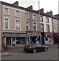
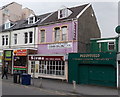
Jasmin boutique, Swansea
On the corner of St Helen's Road and Richardson Street.
Image: © Jaggery
Taken: 27 Apr 2014
0.04 miles
4

Visions Creative, Swansea
Design, print and marketing business on the corner of Oxford Street and Richardson Street,
opposite Pant-y-Gwydr restaurant. http://www.geograph.org.uk/photo/3958333
Image: © Jaggery
Taken: 27 Apr 2014
0.05 miles
5

Sandfields boundary sign, Swansea
Looking along Richardson Street from St Helen's Road. Sandfields is a district of Swansea.
Image: © Jaggery
Taken: 27 Apr 2014
0.05 miles
6
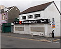
Rowlands Music, Swansea
Musical instruments shop on the corner of St Helen's Road and Richardson Street.
Image: © Jaggery
Taken: 27 Apr 2014
0.06 miles
7

Pant-y-Gwydr restaurant, Swansea
The building on the corner of Oxford Street and Richardson Street used to be a pub, the Pantygwydr Hotel, built in 1870. After nearly three years of restoration and redecoration, the Pant-y-Gwydr restaurant opened on July 14th 2010.
Image: © Jaggery
Taken: 27 Apr 2014
0.06 miles
8
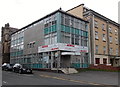
Morse and Valerio, Swansea
The board on the Henrietta Street office shows John Morse Solicitors incorporating Michelle Valerio.
Image: © Jaggery
Taken: 27 Apr 2014
0.07 miles
9
Paddyfield in Swansea
Paddyfield on the right is a Chinese cuisine takeaway in St Helen's Road.
Also in view are Surma, Indian cuisine restaurant & takeaway, The Beach Barber and Tanvir Travel.
Image: © Jaggery
Taken: 27 Apr 2014
0.07 miles
10
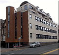
154-155 St Helens Road, Swansea
This is the Henrietta Street side of an apartment block at 154-155 St Helens Road.
Image: © Jaggery
Taken: 27 Apr 2014
0.07 miles