IMAGES TAKEN NEAR TO
Trostre Retail Park, LLANELLI, SA14 9UY
Introduction
This page details the photographs taken nearby to Trostre Retail Park, SA14 9UY by members of the Geograph project.
The Geograph project started in 2005 with the aim of publishing, organising and preserving representative images for every square kilometre of Great Britain, Ireland and the Isle of Man.

There are currently over 7.5m images from over14,400 individuals and you can help contribute to the project by visiting https://www.geograph.org.uk
Image Map
Images are licensed for reuse under creativecommons.org/licenses/by-sa/2.0
Notes
- Clicking on the map will re-center to the selected point.
- The higher the marker number, the further away the image location is from the centre of the postcode.
Image Listing (10 Images Found)
Images are licensed for reuse under creativecommons.org/licenses/by-sa/2.0
Image
Details
Distance
1
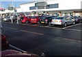
New development at Parc Trostre
M+S - one of many big names that have followed the national trend of vacating the town centres without a backward glance. Parc Trostre is the new Llanelli. Luckily the 'old' Llanelli seems to be holding strong, but has definitely acquired a slightly different feel since the exodus took hold.
Image: © Deborah Tilley
Taken: 18 Jan 2009
0.04 miles
2
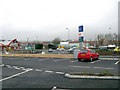
Parc Trostre
Parc Trostre, canolfan siopa tu fas i'r dre.
Parc Trostre, an out of town shopping centre.
Image: © Alan Richards
Taken: 30 Jan 2018
0.08 miles
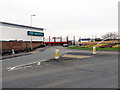
3
Parc Trostre
Industrial units at Parc Trostre, Llanelli.
Image: © Alan Hughes
Taken: 26 Jun 2019
0.09 miles
4
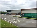
New development Llanelli
It's always nice to see new developments with character.
This one is in Llanelli.
Image: © Dara Jasumani
Taken: 31 Mar 2006
0.11 miles
5
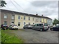
Terraced houses
A row of terraced houses near Parc Trostre, Llanelli.
Image: © Alan Hughes
Taken: 26 Jun 2019
0.17 miles
7
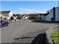
Towards the southeast end of Y Llwyn, Llanelli
Y Llwyn is a cul-de-sac extending for about 100 metres from the SE side of Coed Cae Road.
A short side arm is on the right. http://www.geograph.org.uk/photo/5262290
Image: © Jaggery
Taken: 10 Mar 2016
0.22 miles
8
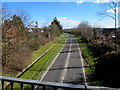
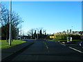
A484 on the southeast side of a footbridge, Llanelli
Viewed from here. http://www.geograph.org.uk/photo/5262354
Image: © Jaggery
Taken: 10 Mar 2016
0.24 miles
9
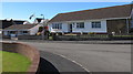
Y Llwyn bungalows, Llanelli
Part of a side arm of Y Llwyn, aligned at right angles to the main course of Y Llwyn.
Image: © Jaggery
Taken: 10 Mar 2016
0.24 miles
10
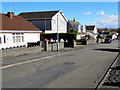
Y Llwyn houses, Llanelli
Y Llwyn is a cul-de-sac on the east side of Coed Cae Road.
Image: © Jaggery
Taken: 10 Mar 2016
0.25 miles