IMAGES TAKEN NEAR TO
Penllwyngwyn Road, LLANELLI, SA14 9UF
Introduction
This page details the photographs taken nearby to Penllwyngwyn Road, SA14 9UF by members of the Geograph project.
The Geograph project started in 2005 with the aim of publishing, organising and preserving representative images for every square kilometre of Great Britain, Ireland and the Isle of Man.

There are currently over 7.5m images from over14,400 individuals and you can help contribute to the project by visiting https://www.geograph.org.uk
Image Map
Images are licensed for reuse under creativecommons.org/licenses/by-sa/2.0
Notes
- Clicking on the map will re-center to the selected point.
- The higher the marker number, the further away the image location is from the centre of the postcode.
Image Listing (3 Images Found)
Images are licensed for reuse under creativecommons.org/licenses/by-sa/2.0
Image
Details
Distance
1
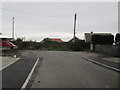
Bryn Harddfan
The end of Harddfan Road marks the top of the hill (75m).
Image: © Adrian Dust
Taken: 6 Nov 2014
0.07 miles
2
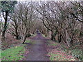
Llwybr y Bryn / Bryn Footpath
Hen ddramffordd a gludai lo o waith bach ger pentre'r Bryn. Mae'r ffordd bellach yn llwybr cyhoeddus dymunol.
A former tram-road that carried coal from a small mine near the village of Bryn (trans. hill). It is today a pleasant public footpath.
Image: © Alan Richards
Taken: 30 Jan 2018
0.19 miles
3
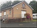
Neuadd y Bryn / Bryn Hall
The community hall for Bryn
Image: © CapG
Taken: 3 Sep 2022
0.21 miles