IMAGES TAKEN NEAR TO
Parc Richard, LLANELLI, SA14 9PF
Introduction
This page details the photographs taken nearby to Parc Richard, SA14 9PF by members of the Geograph project.
The Geograph project started in 2005 with the aim of publishing, organising and preserving representative images for every square kilometre of Great Britain, Ireland and the Isle of Man.

There are currently over 7.5m images from over14,400 individuals and you can help contribute to the project by visiting https://www.geograph.org.uk
Image Map
Images are licensed for reuse under creativecommons.org/licenses/by-sa/2.0
Notes
- Clicking on the map will re-center to the selected point.
- The higher the marker number, the further away the image location is from the centre of the postcode.
Image Listing (13 Images Found)
Images are licensed for reuse under creativecommons.org/licenses/by-sa/2.0
Image
Details
Distance
1

Llwybr Brynmartin / Brynmartin's Path
Llwybr cyhoeddus yn mynd i gyfeiriad Brynmartin.
A public footpath heading in the direction of Brynmartin.
Image: © Alan Richards
Taken: 30 Jan 2018
0.18 miles
2
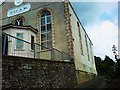
Soar Baptist Chapel
Situated on a lane immediately off the Llwynhendy Road. The graveyard slopes steeply on the north side up and away from the church. To the south are glorious views of the Loughor Estuary
Image: © Deborah Tilley
Taken: 22 Jul 2011
0.22 miles
3
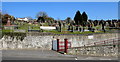
Soar chapelyard, Llwynhendy
A small part of a large burial ground near Soar Baptist Chapel, http://www.geograph.org.uk/photo/4872778 viewed from the B4297 Tanygraig Road.
Image: © Jaggery
Taken: 17 Mar 2016
0.22 miles
4

Mobile Library van in Llwynhendy
This is one of four Carmarthenshire County Council Mobile Library Service vans that visit villages and rural areas in the county without a permanent community library. Each van carries a choice of books for adults and children, in English and in Welsh, including popular fiction and non-fiction, as well as large print titles. Audio and visual material is also available.
Image: © Jaggery
Taken: 17 Mar 2016
0.23 miles
5
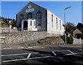
Soar Baptist Chapel, Llwynhendy
The chapel was erected in 1850 above what is now Soar Road. Viewed across the B4297 Tanygraig Road.
The Welsh inscription on the building is Capel y Bedyddwyr Soar Llwynhendy (Soar Baptist Chapel Llwynhendy).
Image: © Jaggery
Taken: 17 Mar 2016
0.23 miles
6
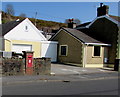
Postbox in a Tanygraig Road wall, Llwynhendy
The postbox is 20th century Elizabethan. http://www.geograph.org.uk/photo/4873270
Image: © Jaggery
Taken: 17 Mar 2016
0.23 miles
7
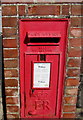
Queen Elizabeth II postbox, Llwynhendy
In the wall here. http://www.geograph.org.uk/photo/4873265
Image: © Jaggery
Taken: 17 Mar 2016
0.23 miles
8
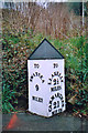
Old Milepost by the B4297, Tanygraig Road, Llanelli Parish
Carmarthen pyramid by the B4297 (was A4240), in parish of Llanelli (Carmarthenshire District), Tanygraig Road, Llwynhendy.
Inscription reads:- : TO / SWANSEA / 9 / MILES : : TO / LLANELLY / 2½ / MILES / CARMARTHEN / 21 / MILES :
Surveyed
Milestone Society National ID: CAM_CMSW21
Image: © Milestone Society
Taken: Unknown
0.23 miles
9
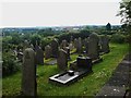
Soar Graveyard
On a steep sided south facing slope. The Trostre works is in the far dostance
Image: © Deborah Tilley
Taken: 22 Jul 2011
0.23 miles
10
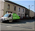
Monkey Tree Care van in Llwynhendy
The distinctive van is parked in Tanygraig Road Llwynhendy near the Bynea boundary. Monkey Tree Care Tree Solutions is based in Swansea. The business's website states "we will climb & cut trees anywhere in the UK".
Image: © Jaggery
Taken: 17 Mar 2016
0.24 miles