IMAGES TAKEN NEAR TO
Gelli Road, LLANELLI, SA14 9AD
Introduction
This page details the photographs taken nearby to Gelli Road, SA14 9AD by members of the Geograph project.
The Geograph project started in 2005 with the aim of publishing, organising and preserving representative images for every square kilometre of Great Britain, Ireland and the Isle of Man.

There are currently over 7.5m images from over14,400 individuals and you can help contribute to the project by visiting https://www.geograph.org.uk
Image Map (Loading...)


Getting Data...Please wait
Leaflet Map data © OpenStreetMap
Images are licensed for reuse under creativecommons.org/licenses/by-sa/2.0
Notes
- Clicking on the map will re-center to the selected point.
- The higher the marker number, the further away the image location is from the centre of the postcode.
Image Listing (11 Images Found)
Images are licensed for reuse under creativecommons.org/licenses/by-sa/2.0
Image
Details
Distance
1
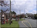
Bus stop near Pemberton
A bus stop on the route from Llanelli to Pontarddulais. In the distance, one of the many chapels of the area can be seen.
Image: © Hywel Williams
Taken: 11 Apr 2008
0.01 miles
3
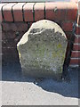
Mile Stone, Llanelli 2 Miles
There is an Ordnance Survey Rivet on the top. http://www.geograph.org.uk/photo/4037775
Image: © Adrian Dust
Taken: 22 Jun 2014
0.14 miles
4
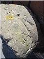
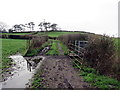
Ordnance Survey Rivet
This OS rivet can be found on the mile stone to the south of the road. It marks a point 47.518m above mean sea level. http://www.geograph.org.uk/photo/4037773
Image: © Adrian Dust
Taken: 22 Jun 2014
0.14 miles
5
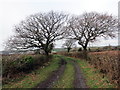
Heol las ger y Bryn / Green road near Bryn
Heol las a llwybr cyhoeddus yn arwain at gaeau.
A green lane and public footpath heading towards fields.
Image: © Alan Richards
Taken: 30 Jan 2018
0.18 miles
6
Tuag at y Bryn / Towards Bryn
Llwybr cyhoeddus yn mynd i gyfeiriad pentre'r Bryn.
A public footpath heading in the direction of Bryn village (trans. hill)
Image: © Alan Richards
Taken: 30 Jan 2018
0.20 miles
7
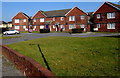
Houses between Heol Gwili and Brynsierfel, Llwynhendy
Set back 25 metres from Heol Gwili. The street named Brynsierfel is behind the houses.
Image: © Jaggery
Taken: 17 Mar 2016
0.20 miles
8
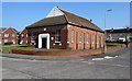
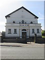
Bethel Presbyterian Church, Llwynhendy
Viewed across Heol Gwili. The nameboard at the edge of the doorway shows Bethel Presbyterian Church.
The inscription on the tablet over the doorway shows BETHEL FORWARD MOVEMENT CHAPEL 1955.
Image: © Jaggery
Taken: 17 Mar 2016
0.21 miles
9
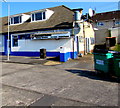
Samraat Curry House, Llwynhendy
Viewed across Heol Gwili.
Image: © Jaggery
Taken: 17 Mar 2016
0.22 miles
10
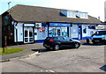
Heol Gwili shops, Llwynhendy
A Lifestyle Express convenience store is flanked by Bonnie's Hair Design on the left
and Samraat Curry House http://www.geograph.org.uk/photo/4876476 behind the van on the right.
Image: © Jaggery
Taken: 17 Mar 2016
0.22 miles