IMAGES TAKEN NEAR TO
Llangennech, LLANELLI, SA14 8YB
Introduction
This page details the photographs taken nearby to SA14 8YB by members of the Geograph project.
The Geograph project started in 2005 with the aim of publishing, organising and preserving representative images for every square kilometre of Great Britain, Ireland and the Isle of Man.

There are currently over 7.5m images from over14,400 individuals and you can help contribute to the project by visiting https://www.geograph.org.uk
Image Map
Images are licensed for reuse under creativecommons.org/licenses/by-sa/2.0
Notes
- Clicking on the map will re-center to the selected point.
- The higher the marker number, the further away the image location is from the centre of the postcode.
Image Listing (43 Images Found)
Images are licensed for reuse under creativecommons.org/licenses/by-sa/2.0
Image
Details
Distance
1
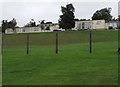
Junior School above Infants School, Llangennech
Llangennech Junior School http://www.geograph.org.uk/photo/4629389 viewed from the entrance http://www.geograph.org.uk/photo/4629462 to Llangennech Infants School.
Image: © Jaggery
Taken: 20 Aug 2015
0.00 miles
2
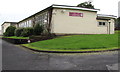
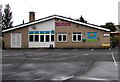
Llangennech Junior School
Llangennech Junior School (Ysgol Iau Llangennech in Welsh) viewed through the Maes y Dderwen entrance gate.
Image: © Jaggery
Taken: 20 Aug 2015
0.01 miles
3
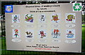
Waste products disposal by nature times, Llangennech
Located at the Maes y Dderwen entrance to Llangennech Junior School. http://www.geograph.org.uk/photo/4629389 The information board shows the time it takes nature to dispose of various waste products, from 6 months for vegetables and matches,
75 years for disposable nappies, 450 years for plastic bottles and never for glass and foam.
In summary, we *all* need to refuse, reduce, reuse, repair and recycle. The target is zero waste.
Image: © Jaggery
Taken: 20 Aug 2015
0.05 miles
4
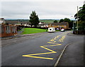
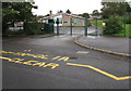
Zigzag road markings on Maes y Dderwen, Llangennech
Marking a Keep Clear (No Parking) zone near the entrance to Llangennech Junior School. http://www.geograph.org.uk/photo/4629389
Image: © Jaggery
Taken: 20 Aug 2015
0.05 miles
5
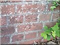
Ordnance Survey Cut Mark
This OS cut mark can be found on the wall of the school. It marks a point 27.981m above mean sea level.
Image: © Adrian Dust
Taken: 10 May 2021
0.05 miles
6
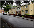
Row of four houses, Maes y Dderwen, Llangennech
The nameplate on the side of the houses shows MAESYDDERWEN (no spaces) whereas
the name signs at both ends of the road show MAES Y DDERWEN (one space each side of the Y).
Image: © Jaggery
Taken: 20 Aug 2015
0.07 miles
7
Llangennech Infants School entrance gates
Viewed across Maes y Dderwen.
Image: © Jaggery
Taken: 20 Aug 2015
0.09 miles
8
Llangennech Infants School
Llangennech Infants School (Ysgol Babanod Llangennech in Welsh) viewed from Maes y Dderwen.
Image: © Jaggery
Taken: 20 Aug 2015
0.09 miles
9
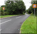
Start of the 30 zone in Llangennech
At the northern edge of the village, the 40mph speed limit on the A4138 drops to 30mph along Maes y Dderwen.
Image: © Jaggery
Taken: 20 Aug 2015
0.09 miles
10
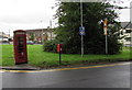
Phonebox and postbox in Llangennech
At the southern end of Maes y Dderwen, near the B4297 Pontarddulais Road junction.
Image: © Jaggery
Taken: 20 Aug 2015
0.10 miles