IMAGES TAKEN NEAR TO
Afon Road, LLANELLI, SA14 8TS
Introduction
This page details the photographs taken nearby to Afon Road, SA14 8TS by members of the Geograph project.
The Geograph project started in 2005 with the aim of publishing, organising and preserving representative images for every square kilometre of Great Britain, Ireland and the Isle of Man.

There are currently over 7.5m images from over14,400 individuals and you can help contribute to the project by visiting https://www.geograph.org.uk
Image Map
Images are licensed for reuse under creativecommons.org/licenses/by-sa/2.0
Notes
- Clicking on the map will re-center to the selected point.
- The higher the marker number, the further away the image location is from the centre of the postcode.
Image Listing (88 Images Found)
Images are licensed for reuse under creativecommons.org/licenses/by-sa/2.0
Image
Details
Distance
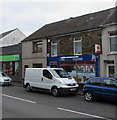
1

Afon Road houses, Llangennech
Viewed across the B4297 Afon Road from the corner of Maes Road.
Image: © Jaggery
Taken: 20 Aug 2015
0.02 miles
2
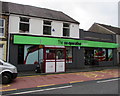
The Co-operative Food Store in Llangennech
Viewed across Afon Road.
Image: © Jaggery
Taken: 20 Aug 2015
0.03 miles
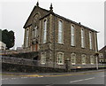
3
Salem Chapel
Llangennech - Salem Chapel.
Image: © Alan Hughes
Taken: 7 Sep 2018
0.04 miles
4
Lifestyle Express and Post Office, Llangennech
In August 2015, the village post office is a counter in this Afon Road convenience store.
An August 2011 Google Earth Street View shows a Bargain Booze Extra here.
Image: © Jaggery
Taken: 20 Aug 2015
0.04 miles
5

Rusty roofed building on a Llangennech corner
On the corner of Maes Road and Afon Road, viewed across the B4297 from the corner of Park Lane.
The rusty roof makes this building easy to spot on satellite images.
Image: © Jaggery
Taken: 20 Aug 2015
0.04 miles
6

Corner of Afon Road and Maes Road, Llangennech
In August 2015, there is no nameboard on these business premises to indicate their current use, if any.
Image: © Jaggery
Taken: 20 Aug 2015
0.04 miles
7
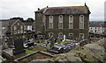
Salem chapelyard and chapel, Llangennech
Viewed from Bank Road. See http://www.geograph.org.uk/photo/4624563 and http://www.geograph.org.uk/photo/4624568 for other views of Salem chapel.
Image: © Jaggery
Taken: 20 Aug 2015
0.04 miles
8
Afon Road side of Salem chapel, Llangennech
http://www.geograph.org.uk/photo/4624563 to the Bank Road side and a few details.
Image: © Jaggery
Taken: 20 Aug 2015
0.04 miles
9
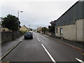
Maes Road, Llangennech
Looking SSE from the corner of the B4297.
Image: © Jaggery
Taken: 20 Aug 2015
0.05 miles
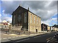
10
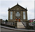
Grade II listed Salem chapel, Llangennech
This is the Bank Road side of the building on the corner of Afon Road.
SALEM BAPTIST CHAPEL and the year 1878 is inscribed on the roundel above the central windows.
In August 2015 the nameboard in Welsh only shows SALEM EGLWYS Y BEDYDDWYR (Baptist Church).
http://www.geograph.org.uk/photo/4624568 to a view across Afon Road.
Image: © Jaggery
Taken: 20 Aug 2015
0.05 miles