IMAGES TAKEN NEAR TO
Maes Penrhyn, LLANELLI, SA14 8RJ
Introduction
This page details the photographs taken nearby to Maes Penrhyn, SA14 8RJ by members of the Geograph project.
The Geograph project started in 2005 with the aim of publishing, organising and preserving representative images for every square kilometre of Great Britain, Ireland and the Isle of Man.

There are currently over 7.5m images from over14,400 individuals and you can help contribute to the project by visiting https://www.geograph.org.uk
Image Map (Loading...)


Getting Data...Please wait
Leaflet Map data © OpenStreetMap
Images are licensed for reuse under creativecommons.org/licenses/by-sa/2.0
Notes
- Clicking on the map will re-center to the selected point.
- The higher the marker number, the further away the image location is from the centre of the postcode.
Image Listing (43 Images Found)
Images are licensed for reuse under creativecommons.org/licenses/by-sa/2.0
Image
Details
Distance
1
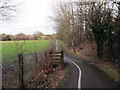
Tuag at Ddafen / Towards Dafen
Llwybr beicio yn mynd i gyfeiriad Dafen.
A cycle path heading in the direction of Dafen.
Image: © Alan Richards
Taken: 30 Jan 2018
0.08 miles
2
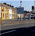
Junction in Pemberton, Llanelli
Viewed across Llandafen Road which splits into Gelli Road towards Bryn and Llangennech on the left and Pemberton Road towards Llwynhendy and Bynea on the right.
Image: © Jaggery
Taken: 17 Mar 2016
0.11 miles
3
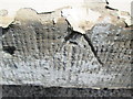
Ordnance Survey Rivet
This OS rivet can be found on the window sill of No2 Pemberton Road. It marks a point 22.001m above mean sea level.
Image: © Adrian Dust
Taken: 22 Jun 2014
0.11 miles
4
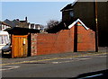
Pemberton Square electricity substation, Llanelli
The Western Power Distribution electricity substation, identifer PEMBERTON SQUARE
S/S 52-1662, is in the brick structure on the north side of Pemberton Road.
Image: © Jaggery
Taken: 17 Mar 2016
0.12 miles
5
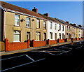
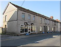
Houses and front walls, Llandafen Road, Pemberton, Llanelli
On the north side of the B4297 Llandafen Road in the Pemberton area of Llanelli.
Image: © Jaggery
Taken: 17 Mar 2016
0.13 miles
6
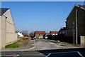
Unnamed side road, Pemberton, Llanelli
On the north side of the B4297 Llandafen Road in the Pemberton area of Llanelli.
Image: © Jaggery
Taken: 17 Mar 2016
0.14 miles
7
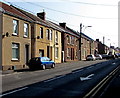
Houses and satellite dishes, Pemberton Road, Llanelli
Satellite dishes are at various heights above the pavement, but none on roofs.
Image: © Jaggery
Taken: 17 Mar 2016
0.14 miles
8
Ordnance Survey Rivet
This OS rivet can be found on the wall of Bronwydd House. It marks a point 31.099m above mean sea level.
Image: © Adrian Dust
Taken: 22 Jun 2014
0.14 miles
9
Independent Hair & Beauty salon, Llanelli
At 43 Pemberton Road.
Image: © Jaggery
Taken: 17 Mar 2016
0.15 miles
10
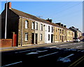
Row of houses, Llandafen Road, Pemberton, Llanelli
On the north side of the B4297 Llandafen Road in the Pemberton area of Llanelli.
Image: © Jaggery
Taken: 17 Mar 2016
0.16 miles