IMAGES TAKEN NEAR TO
Bryn Rhos, LLANELLI, SA14 8RB
Introduction
This page details the photographs taken nearby to Bryn Rhos, SA14 8RB by members of the Geograph project.
The Geograph project started in 2005 with the aim of publishing, organising and preserving representative images for every square kilometre of Great Britain, Ireland and the Isle of Man.

There are currently over 7.5m images from over14,400 individuals and you can help contribute to the project by visiting https://www.geograph.org.uk
Image Map (Loading...)


Getting Data...Please wait
Leaflet Map data © OpenStreetMap
Images are licensed for reuse under creativecommons.org/licenses/by-sa/2.0
Notes
- Clicking on the map will re-center to the selected point.
- The higher the marker number, the further away the image location is from the centre of the postcode.
Image Listing (14 Images Found)
Images are licensed for reuse under creativecommons.org/licenses/by-sa/2.0
Image
Details
Distance
1
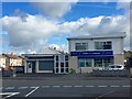
Local shops
Local Stores in Penceiliogi.
Image: © Alan Hughes
Taken: 7 Sep 2018
0.05 miles
2
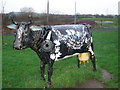
The Cow
Any further info/reminiscences about the scrap metal masterpiece in Penceiliogi?
Image: © Ronald John Saunders
Taken: 17 Jan 2007
0.08 miles
3
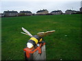
The Bee
One of two public sculptures in Penceiliogi.
Image: © Ronald John Saunders
Taken: 17 Jan 2007
0.10 miles
4
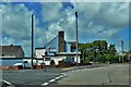
Road Junction At Cefn Caeau
A public house sits at the junction
Image: © Deborah Tilley
Taken: 6 Jun 2015
0.12 miles
5
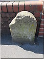
Mile Stone, Llanelli 2 Miles
There is an Ordnance Survey Rivet on the top. http://www.geograph.org.uk/photo/4037775
Image: © Adrian Dust
Taken: 22 Jun 2014
0.13 miles
6
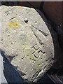
Ordnance Survey Rivet
This OS rivet can be found on the mile stone to the south of the road. It marks a point 47.518m above mean sea level. http://www.geograph.org.uk/photo/4037773
Image: © Adrian Dust
Taken: 22 Jun 2014
0.13 miles
7
Ordnance Survey Rivet
This OS rivet can be found on the wall of Bronwydd House. It marks a point 31.099m above mean sea level.
Image: © Adrian Dust
Taken: 22 Jun 2014
0.17 miles
8
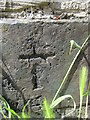
Ordnance Survey Cut Mark
This incomplete OS cut mark can be found on No4 Gors Fach. It marks a point 17.066m above mean sea level.
Image: © Adrian Dust
Taken: 22 Jun 2014
0.21 miles
9
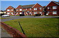
Houses between Heol Gwili and Brynsierfel, Llwynhendy
Set back 25 metres from Heol Gwili. The street named Brynsierfel is behind the houses.
Image: © Jaggery
Taken: 17 Mar 2016
0.22 miles
10
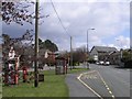
Bus stop near Pemberton
A bus stop on the route from Llanelli to Pontarddulais. In the distance, one of the many chapels of the area can be seen.
Image: © Hywel Williams
Taken: 11 Apr 2008
0.23 miles