IMAGES TAKEN NEAR TO
Brynheulog, LLANELLI, SA14 8AF
Introduction
This page details the photographs taken nearby to Brynheulog, SA14 8AF by members of the Geograph project.
The Geograph project started in 2005 with the aim of publishing, organising and preserving representative images for every square kilometre of Great Britain, Ireland and the Isle of Man.

There are currently over 7.5m images from over14,400 individuals and you can help contribute to the project by visiting https://www.geograph.org.uk
Image Map
Images are licensed for reuse under creativecommons.org/licenses/by-sa/2.0
Notes
- Clicking on the map will re-center to the selected point.
- The higher the marker number, the further away the image location is from the centre of the postcode.
Image Listing (9 Images Found)
Images are licensed for reuse under creativecommons.org/licenses/by-sa/2.0
Image
Details
Distance
2
Track opposite Ysgol y Felin, Llanelli
A public footpath runs on the gravel track opposite the school.
Image: © M J Roscoe
Taken: 1 Oct 2021
0.12 miles
3
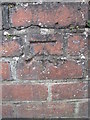
Ordnance Survey Cut Mark
This OS cut mark can be found on the wall of No59 Glasfryn. It marks a point 38.448m above mean sea level.
Image: © Adrian Dust
Taken: 17 Aug 2014
0.13 miles
4
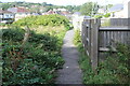
Footpath to Heol Daniel, Llanelli
Path between Afon Lliedi and gardens.
Image: © M J Roscoe
Taken: 1 Oct 2021
0.14 miles
5
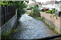
Afon Lliedi behind Maeswerdd
River in spate downstream from footbridge.
Image: © M J Roscoe
Taken: 1 Oct 2021
0.16 miles
6
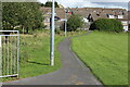
Public footpath to Brynsiriol
Path on the edge of Llanerch & Penygaer Playing Field; viewed from end of footbridge.
Image: © M J Roscoe
Taken: 1 Oct 2021
0.17 miles
7
Children's playground
The fence round the cemetery can be seen on the left, and the mast at Image is visible on the skyline.
Image: © Marion Phillips
Taken: 16 Feb 2010
0.17 miles
8
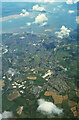
Llanelli from the air, 1998
Conspicuous in the centre is the schools' stadium. The white building to the right of it is the Marelli works, now much expanded. Beyond the town is the estuary of the River Loughor.
Image: © Derek Harper
Taken: 1 Jun 1998
0.21 miles
9
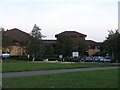
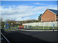
Prince Philip Hospital, Llanelli
Prince Philip Hospital is part of the Carmarthenshire NHS trust and provides full Accident & Emergency support for the area.
Image: © Hywel Williams
Taken: 19 Sep 2006
0.25 miles