IMAGES TAKEN NEAR TO
Carmel, LLANELLI, SA14 7TP
Introduction
This page details the photographs taken nearby to SA14 7TP by members of the Geograph project.
The Geograph project started in 2005 with the aim of publishing, organising and preserving representative images for every square kilometre of Great Britain, Ireland and the Isle of Man.

There are currently over 7.5m images from over14,400 individuals and you can help contribute to the project by visiting https://www.geograph.org.uk
Image Map
Images are licensed for reuse under creativecommons.org/licenses/by-sa/2.0
Notes
- Clicking on the map will re-center to the selected point.
- The higher the marker number, the further away the image location is from the centre of the postcode.
Image Listing (3 Images Found)
Images are licensed for reuse under creativecommons.org/licenses/by-sa/2.0
Image
Details
Distance
1
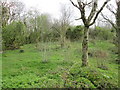
Woodland Management
Garn, 257m high point.
Image: © Adrian Dust
Taken: 24 Apr 2014
0.14 miles
2
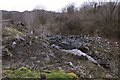
Disused quarry in Carmel National Nature Reserve
Most of this parcel of the nature reserve is a small or large quarry from the past that is slowly returning to the wild. This is part of the largest quarry. There are still some huge exposed slabs. This particular part seems to have been abandoned during being worked.
Image: © Nigel Davies
Taken: 23 Jan 2011
0.20 miles
3
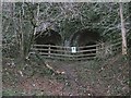
Lime Kilns in Carmel National Nature Reserve
This part of the reserve, enclosed by roads, has many old abandoned quarries. In fact a swathe of land running beyond to the east and west has been used for limestone quarrying at one time or other. Like many with any significant sized chamber intact, these kilns have been blocked off for safety.
Image: © Nigel Davies
Taken: 23 Jan 2011
0.22 miles