IMAGES TAKEN NEAR TO
Maesybont, LLANELLI, SA14 7SY
Introduction
This page details the photographs taken nearby to SA14 7SY by members of the Geograph project.
The Geograph project started in 2005 with the aim of publishing, organising and preserving representative images for every square kilometre of Great Britain, Ireland and the Isle of Man.

There are currently over 7.5m images from over14,400 individuals and you can help contribute to the project by visiting https://www.geograph.org.uk
Image Map (Loading...)


Getting Data...Please wait
Leaflet Map data © OpenStreetMap
Images are licensed for reuse under creativecommons.org/licenses/by-sa/2.0
Notes
- Clicking on the map will re-center to the selected point.
- The higher the marker number, the further away the image location is from the centre of the postcode.
Image Listing (9 Images Found)
Images are licensed for reuse under creativecommons.org/licenses/by-sa/2.0
Image
Details
Distance
1
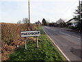
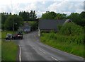
Cyrraedd Maesybont / Entering Maesybont
Pentre Maesybont a'r B4297.
Maesybont (trans. field at the bridge) village and the B4297.
Image: © Alan Richards
Taken: 5 Feb 2020
0.08 miles
2
Gate with Bryn-yr-odin farm in background.
Image: © John Duckfield
Taken: 2 Jun 2009
0.13 miles
5

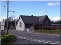
Hen lythyrdy / Former post office
Hen lythyrdy ym mhentre Maesybont.
A former post office at Maesybont village (trans. field at the bridge).
Image: © Alan Richards
Taken: 5 Feb 2020
0.19 miles
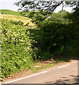
7
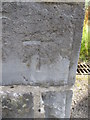
Ordnance Survey Cut Mark
This OS cut mark can be found on the NE parapet of the bridge over the Gwendraeth Fach. It marks a point 196.16m above mean sea level.
Image: © Adrian Dust
Taken: 30 Jul 2015
0.21 miles
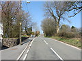
8
Junction and bridge in Maesybont
The gentlemen by the lorry were having a heated argument in Welsh.
Image: © Colin Bell
Taken: 20 Jun 2008
0.24 miles
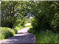
9

Maesybont - minor road junction with B4297
Image: © Stuart Logan
Taken: 4 Oct 2011
0.25 miles