IMAGES TAKEN NEAR TO
Maesybont, LLANELLI, SA14 7ST
Introduction
This page details the photographs taken nearby to SA14 7ST by members of the Geograph project.
The Geograph project started in 2005 with the aim of publishing, organising and preserving representative images for every square kilometre of Great Britain, Ireland and the Isle of Man.

There are currently over 7.5m images from over14,400 individuals and you can help contribute to the project by visiting https://www.geograph.org.uk
Image Map (Loading...)


Getting Data...Please wait
Leaflet Map data © OpenStreetMap
Images are licensed for reuse under creativecommons.org/licenses/by-sa/2.0
Notes
- Clicking on the map will re-center to the selected point.
- The higher the marker number, the further away the image location is from the centre of the postcode.
Image Listing (4 Images Found)
Images are licensed for reuse under creativecommons.org/licenses/by-sa/2.0
Image
Details
Distance
1
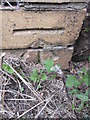
Ordnance Survey Cut Mark
This OS cut mark can be found on the wall post of Glannant Farm. It marks a point 203.94m above mean sea level.
Image: © Adrian Dust
Taken: 30 Jul 2015
0.21 miles
2

Pond in field
Pond in a field near Maesybont.
Image: © Alan Hughes
Taken: 19 Nov 2018
0.23 miles
3
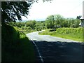
Country road near Measybont
An unclassified minor country road near Measybont.
Image: © Philip Halling
Taken: 15 Jun 2021
0.25 miles
4
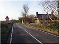
Ffarm Ffynnon Lwyd / Ffynnon Lwyd Farm
Ffarm Ffynnon Lwyd yn cael ei hadnewyddu ar ol bod yn wag am flynyddau.
Ffynnon Lwyd Farm (trans. holy or muddy spring /well) being renovated after being empty for years.
Image: © Alan Richards
Taken: 5 Feb 2020
0.25 miles