IMAGES TAKEN NEAR TO
Bryncwar Road, LLANELLI, SA14 7PG
Introduction
This page details the photographs taken nearby to Bryncwar Road, SA14 7PG by members of the Geograph project.
The Geograph project started in 2005 with the aim of publishing, organising and preserving representative images for every square kilometre of Great Britain, Ireland and the Isle of Man.

There are currently over 7.5m images from over14,400 individuals and you can help contribute to the project by visiting https://www.geograph.org.uk
Image Map (Loading...)


Getting Data...Please wait
Leaflet Map data © OpenStreetMap
Images are licensed for reuse under creativecommons.org/licenses/by-sa/2.0
Notes
- Clicking on the map will re-center to the selected point.
- The higher the marker number, the further away the image location is from the centre of the postcode.
Image Listing (5 Images Found)
Images are licensed for reuse under creativecommons.org/licenses/by-sa/2.0
Image
Details
Distance
1
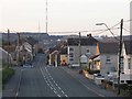
Pen-y-Groes
A view of Pen-y-Groes, looking towards the Carmel TV, radio and communications masts. The second smaller mast had only been erected a few days before this picture was taken.
Image: © Hywel Williams
Taken: 4 Nov 2006
0.07 miles
2
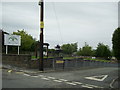
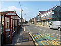
Road junction, Pen-y-Groes
A view of the road junction by the children's play area and Pen-y-Groes Primary School.
Image: © Martyn Harries
Taken: 27 Jul 2013
0.08 miles
4
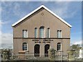
Brickworks
The now demolished Emlyn Brickworks in Pen-y-groes. The OS map says opencast workings but the site had both the coal workings and the brickworks until the colliery closed in 1939. The brickworks closed in the mid 1990's.
Image: © Dara Jasumani
Taken: 17 Oct 2002
0.18 miles
5
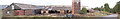
Pentre Penygroes / Penygroes Village
Heol Waterloo yn agosau at y groesffordd ym Mhenygroes.
Waterloo Road approaching the crossroads at Penygroes (trans. top of the crossroads).
Image: © Alan Richards
Taken: 12 Aug 2020
0.25 miles