IMAGES TAKEN NEAR TO
Drefach, LLANELLI, SA14 7BU
Introduction
This page details the photographs taken nearby to SA14 7BU by members of the Geograph project.
The Geograph project started in 2005 with the aim of publishing, organising and preserving representative images for every square kilometre of Great Britain, Ireland and the Isle of Man.

There are currently over 7.5m images from over14,400 individuals and you can help contribute to the project by visiting https://www.geograph.org.uk
Image Map
Images are licensed for reuse under creativecommons.org/licenses/by-sa/2.0
Notes
- Clicking on the map will re-center to the selected point.
- The higher the marker number, the further away the image location is from the centre of the postcode.
Image Listing (9 Images Found)
Images are licensed for reuse under creativecommons.org/licenses/by-sa/2.0
Image
Details
Distance
3
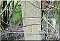
Ordnance Survey Cut Mark
This OS cut mark can be found on the concrete fence post NW side of the road. It marks a point 71.433m above mean sea level.
Image: © Adrian Dust
Taken: 25 Mar 2021
0.09 miles
4
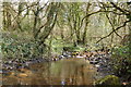
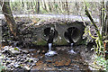
Stream near Tumble
One of many in the vicinity, this running down toward the Gwendraeth Mawr.
Image: © Mick Lobb
Taken: 7 Apr 2009
0.18 miles
7
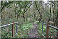
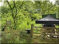
Llwybr cyhoeddus ger Clos Isaf / A public footpath near Clos Isaf
Llwybr cyhoeddus yn gadael yr heol ger Ffarm Clos Isaf.
A public footpath exiting the road near Clos Isaf Farm (trans. lower yard).
Image: © Alan Richards
Taken: 16 Dec 2017
0.22 miles
8
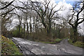
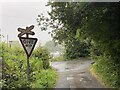
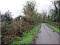
Mine road near Tumble
The road to the left leads to the mine and that to the right back to the B4306.
Image: © Mick Lobb
Taken: 7 Apr 2009
0.23 miles
9
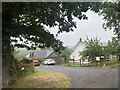
Mieri Eco Farm
Mieri Eco Farm is an off-grid, eco smallholding in Carmarthenshire, following the principles of One Planet Development
Image: © Alan Hughes
Taken: 23 Jul 2022
0.24 miles