IMAGES TAKEN NEAR TO
Heol Cwmmawr, LLANELLI, SA14 7AA
Introduction
This page details the photographs taken nearby to Heol Cwmmawr, SA14 7AA by members of the Geograph project.
The Geograph project started in 2005 with the aim of publishing, organising and preserving representative images for every square kilometre of Great Britain, Ireland and the Isle of Man.

There are currently over 7.5m images from over14,400 individuals and you can help contribute to the project by visiting https://www.geograph.org.uk
Image Map
Images are licensed for reuse under creativecommons.org/licenses/by-sa/2.0
Notes
- Clicking on the map will re-center to the selected point.
- The higher the marker number, the further away the image location is from the centre of the postcode.
Image Listing (14 Images Found)
Images are licensed for reuse under creativecommons.org/licenses/by-sa/2.0
Image
Details
Distance
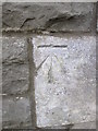
1
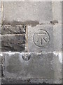
Ordnance Survey Cut Mark
This OS cut mark can be found on the south face of the school. It marks a point 106.89m above mean sea level. http://www.geograph.org.uk/photo/4271756
Image: © Adrian Dust
Taken: 7 Dec 2014
0.05 miles
2
Ysgol Gynradd Drefach
There is an Ordnance Survey cut mark on the SW angle of the school. http://www.geograph.org.uk/photo/4271752
Image: © Adrian Dust
Taken: 7 Dec 2014
0.05 miles
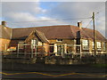
3
Drefach Junior School
View of Drefach Junior School from the west.
Image: © Alan Hughes
Taken: 23 Jan 2019
0.05 miles
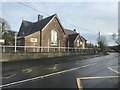
4
Drefach Junior School
View of Drefach Junior School from the south-east.
(I wonder whether the teachers and pupils know that a grid line passes through their school!)
Image: © Alan Hughes
Taken: 23 Jan 2019
0.06 miles
5
Parc Drefach / Drefach Park
Mynediad i Barc Drefach.
Entrance to Drefach Park (trans. little hamlet).
Image: © Alan Richards
Taken: 16 Aug 2020
0.06 miles
6
Ordnance Survey Cut Mark
This OS cut mark can be found on the NW face of the Gwendraeth Valley Grammar School building. It marks a point 101.94m above mean sea level.
Image: © Adrian Dust
Taken: 7 Dec 2014
0.11 miles
7
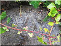
Ordnance Survey Rivet
This OS rivet can be found on the SW parapet of the bridge. It marks a point 96.381m above mean sea level.
Image: © Adrian Dust
Taken: 7 Dec 2014
0.12 miles
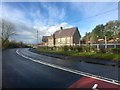
8
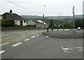
Bend in the road, Drefach
View of the B4310 through Drefach, near the entrance to the local school, Ysgol Gynradd Drefach.
Image: © Martyn Harries
Taken: 29 Sep 2013
0.13 miles
9
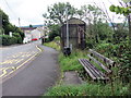
Heol Cwmmawr, Drefach / Cwmmawr Road, Drefach
Arhosfan fysys a mainc cyhoeddus ar Heol Cwmmawr, Drefach.
A bus stop and public bench on Heol Cwmmawr (trans. big valley road), Drefach (trans. little hamlet).
Image: © Alan Richards
Taken: 16 Aug 2020
0.14 miles
10

Old Milestone by Heol Blaenhirwaun, Drefach, Llanddarog parish
Slate post by the UC road (was A48), in parish of Llanddarog (Carmarthenshire District), Drefach, North of village, just East of junction with the B4310. Broken in two.
Inscription reads:-
From
CARMARTHEN
9 Miles
To
SWANSEA
18
Surveyed
Milestone Society National ID: CAM_CMSW09
Image: © Milestone Society
Taken: Unknown
0.15 miles