IMAGES TAKEN NEAR TO
Maesyrhaf, LLANELLI, SA14 6LT
Introduction
This page details the photographs taken nearby to Maesyrhaf, SA14 6LT by members of the Geograph project.
The Geograph project started in 2005 with the aim of publishing, organising and preserving representative images for every square kilometre of Great Britain, Ireland and the Isle of Man.

There are currently over 7.5m images from over14,400 individuals and you can help contribute to the project by visiting https://www.geograph.org.uk
Image Map
Images are licensed for reuse under creativecommons.org/licenses/by-sa/2.0
Notes
- Clicking on the map will re-center to the selected point.
- The higher the marker number, the further away the image location is from the centre of the postcode.
Image Listing (3 Images Found)
Images are licensed for reuse under creativecommons.org/licenses/by-sa/2.0
Image
Details
Distance
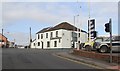
1
Cross Hands Crossroads
Turn left for the Square Shopping Centre, go straight on for Llanelli, turn right for Cefneithin and Drefach, or have a pint in the Cross Hands Inn.
Image: © Marion Phillips
Taken: 24 Nov 2010
0.17 miles
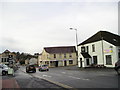
2
Ordnance Survey Rivet
This Ordnance Survey Rivet can be found on a window sill of the Cross Hands Hotel. It marks a point 144.1704m above mean sea level.
Image: © Adrian Dust
Taken: 9 Jun 2013
0.18 miles