IMAGES TAKEN NEAR TO
Gwendraeth Road, LLANELLI, SA14 6HT
Introduction
This page details the photographs taken nearby to Gwendraeth Road, SA14 6HT by members of the Geograph project.
The Geograph project started in 2005 with the aim of publishing, organising and preserving representative images for every square kilometre of Great Britain, Ireland and the Isle of Man.

There are currently over 7.5m images from over14,400 individuals and you can help contribute to the project by visiting https://www.geograph.org.uk
Image Map
Images are licensed for reuse under creativecommons.org/licenses/by-sa/2.0
Notes
- Clicking on the map will re-center to the selected point.
- The higher the marker number, the further away the image location is from the centre of the postcode.
Image Listing (9 Images Found)
Images are licensed for reuse under creativecommons.org/licenses/by-sa/2.0
Image
Details
Distance
1
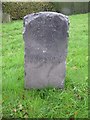
Old Milestone by the B4310, Gwendraeth Road, Llanon parish
Slate post by the B4310, in parish of Llanon (Carmarthenshire District), Gwendraeth Road, at junction with Heol Hirwaun Olau on grass verge.
Inscription reads:-
DREFACH
1
LLETTYMAWR
1
Surveyed
Milestone Society National ID: CAM_DFLR01
Image: © Milestone Society
Taken: Unknown
0.05 miles
2
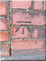
Ordnance Survey Cut Mark
This OS cut mark can be found on the SW brick parapet of the bridge. It marks a point 108.78m above mean sea level.
Image: © Adrian Dust
Taken: 7 Dec 2014
0.05 miles
3
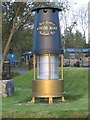
Giant miner's lamp at Mynydd Mawr Woodland Park
Just at the entrance to the park in Tumble there is this giant miner's lamp. Presumably this is because the whole park is situated on a reclaimed colliery.
Image: © Nigel Davies
Taken: 22 Oct 2005
0.09 miles
4
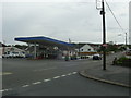
B4310 heading for Tumble
A view from a road junction of the B4310 heading for Tumble from Drefach.
Image: © Martyn Harries
Taken: 28 Sep 2013
0.10 miles
5
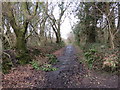
Heol Hirwaun Oleu / Hirwaun Oleu Road
Rhan fach yn unig o hen heol sy'n goroesi a ai at Ffermydd Hirwaun Olau, Fron Olau a Blaen Hirwaun. Mae'r darn a gollwyd bellach yn rhan o Barc Coetir Mynydd Mawr. Mae'r ddwy ffarm gyntaf hefyd wedi diflannu.
Only a small section of road survives which once led to Hirwaun Olau, Fron Olau and Blaen Hirwaun Farms. The lost section is now part of the Mynydd Mawr Woodland Park. The former two farms have also disappeared
Image: © Alan Richards
Taken: 22 Feb 2014
0.17 miles
6
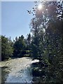
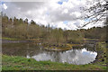
Cwm Mawr
Pond in Cwm Mawr country park.
Image: © Alan Hughes
Taken: 17 Sep 2020
0.20 miles
8
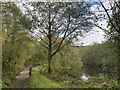
Footpath and lake
Mynydd Mawr Country Park.
Image: © Alan Hughes
Taken: 25 Oct 2022
0.21 miles
9
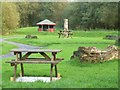
Picnic tables at Mynydd Mawr Woodland Park
This picnic area is near the main car park at the south entrance from Tumble.
Image: © Nigel Davies
Taken: 22 Oct 2005
0.21 miles