IMAGES TAKEN NEAR TO
Rhoslan, LLANELLI, SA14 6DX
Introduction
This page details the photographs taken nearby to Rhoslan, SA14 6DX by members of the Geograph project.
The Geograph project started in 2005 with the aim of publishing, organising and preserving representative images for every square kilometre of Great Britain, Ireland and the Isle of Man.

There are currently over 7.5m images from over14,400 individuals and you can help contribute to the project by visiting https://www.geograph.org.uk
Image Map
Images are licensed for reuse under creativecommons.org/licenses/by-sa/2.0
Notes
- Clicking on the map will re-center to the selected point.
- The higher the marker number, the further away the image location is from the centre of the postcode.
Image Listing (4 Images Found)
Images are licensed for reuse under creativecommons.org/licenses/by-sa/2.0
Image
Details
Distance
2
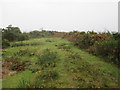
Pen Y Tymbl
The top of Pen Y Tymbl (227m).
Image: © Adrian Dust
Taken: 6 Nov 2014
0.15 miles
3
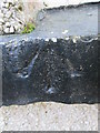
Ordnance Survey Pivot
This OS pivot can be found on the window sill of No49 Heol Y Bryn. It marks a point 181.43m above mean sea level.
Image: © Adrian Dust
Taken: 7 Dec 2014
0.20 miles
4
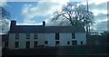
Farm on the Tumble to Cross Hands road
Image: © Deborah Tilley
Taken: 22 Feb 2009
0.25 miles