IMAGES TAKEN NEAR TO
Gors Road, LLANELLI, SA14 6BS
Introduction
This page details the photographs taken nearby to Gors Road, SA14 6BS by members of the Geograph project.
The Geograph project started in 2005 with the aim of publishing, organising and preserving representative images for every square kilometre of Great Britain, Ireland and the Isle of Man.

There are currently over 7.5m images from over14,400 individuals and you can help contribute to the project by visiting https://www.geograph.org.uk
Image Map
Images are licensed for reuse under creativecommons.org/licenses/by-sa/2.0
Notes
- Clicking on the map will re-center to the selected point.
- The higher the marker number, the further away the image location is from the centre of the postcode.
Image Listing (5 Images Found)
Images are licensed for reuse under creativecommons.org/licenses/by-sa/2.0
Image
Details
Distance
1
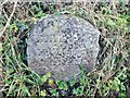
Old Milestone, A476, Llannon Road, Tumble Village
The milestone is located outside no. 47, 20m south of the junction with Gors Road on the east side of the road. Community of Llannon (Carmarthenshire District). Erected in the 19th century.
Inscription reads:
(From) / LLANDILO / (10 Miles) / (To) / LLANELLY / (7½)
Grade II listed by Cadw. Reference Number: 21092 https://cadwpublic-api.azurewebsites.net/reports/listedbuilding/FullReport?lang=&id=21092
Milestone Society National ID: CAM_LOLE10
Image: © Kirstie Hackett
Taken: 4 Feb 2022
0.07 miles
4
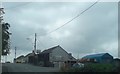
Vintage bus in a vintage garage
This lovely old vehicle has been tucked away for some years.
Image: © Deborah Tilley
Taken: 26 Jul 2008
0.17 miles
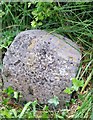
5
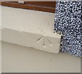
Ordnance Survey Rivet
This OS rivet can be found on No13 Llannon Road. It marks a point 200.281m above mean sea level.
Image: © Adrian Dust
Taken: 3 Jun 2020
0.23 miles