IMAGES TAKEN NEAR TO
Fleet Street, SWANSEA, SA1 3UT
Introduction
This page details the photographs taken nearby to Fleet Street, SA1 3UT by members of the Geograph project.
The Geograph project started in 2005 with the aim of publishing, organising and preserving representative images for every square kilometre of Great Britain, Ireland and the Isle of Man.

There are currently over 7.5m images from over14,400 individuals and you can help contribute to the project by visiting https://www.geograph.org.uk
Image Map
Images are licensed for reuse under creativecommons.org/licenses/by-sa/2.0
Notes
- Clicking on the map will re-center to the selected point.
- The higher the marker number, the further away the image location is from the centre of the postcode.
Image Listing (98 Images Found)
Images are licensed for reuse under creativecommons.org/licenses/by-sa/2.0
Image
Details
Distance
1
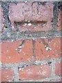
Ordnance Survey Cut Mark
This OS cut mark can be found on the gate post to the customer parking area for 'South Wales Window Blind Centre' on Beach Street.. It marks a point 7.007m above mean sea level.
Image: © Adrian Dust
Taken: 19 Nov 2013
0.05 miles
2

Ordnance Survey Cut Mark
This OS cut mark can be found on the SE corner of the school on Vincent Street. It marks a point 5.874m above mean sea level.
Image: © Adrian Dust
Taken: 19 Nov 2013
0.06 miles
3
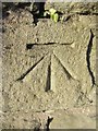
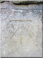
Ordnance Survey Cut Mark
This OS cut mark can be found on the wall of No276 Oystermouth Road. It marks a point 6.614m above mean sea level.
Image: © Adrian Dust
Taken: 19 Nov 2013
0.07 miles
4
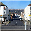
Beach Street Swansea
Viewed across Oystermouth Road. Abertawe Alehouse http://www.geograph.org.uk/photo/3677208 is on the left.
Image: © Jaggery
Taken: 26 Feb 2012
0.07 miles
5

Oyster Hotel, Swansea
The blue building on the right is the Oyster Hotel at 262 Oystermouth Road.
Image: © Jaggery
Taken: 26 Feb 2012
0.07 miles
6

Sea Haven Hotel Swansea
The hotel with its distinctive six dormer windows is at 250 Oystermouth Road.
Image: © Jaggery
Taken: 26 Feb 2012
0.07 miles
7
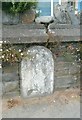
Old Milestone by the A4067, Oystermouth Road, Sandfields, Swansea parish
Stone post by the A4067, in parish of Swansea (City and County of Swansea District), Oystermouth Road, Sandfields, in boundary wall of No. 276 (Morlais Guest House).
Inscription once read:-
(Swansea Castle)
(1)
(The Mumbles)
(4)
Surveyed
Milestone Society National ID: GLA_SWOM01
Image: © Milestone Society
Taken: Unknown
0.08 miles
8

Arches Hotel Swansea
Arches Hotel on the left is at 280 Oystermouth Road.
Morlais Guest House is next door, centre right.
Image: © Jaggery
Taken: 26 Feb 2012
0.08 miles
9
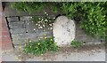
Milestone - Swansea 1
Set into the wall of No276 Oystermouth Road.
Image: © Adrian Dust
Taken: 9 Jul 2021
0.08 miles
10
Ordnance Survey Cut Mark
This OS cut mark can be found on the wall of No27 Argyle Street. It marks a point 5.980m above mean sea level.
Image: © Adrian Dust
Taken: 19 Nov 2013
0.08 miles